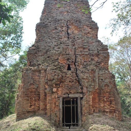
Sambor Temple Group (North Group)
Prasat Sambor is the greatest temple compound among the Sambor Prei Kuk monuments. This compound was a Hindu temple devoted to Shiva. There are several brick shrines and triple enclosure walls surrounding the main tower. […]
Oddar Meanchey Province
Oddar Meanchey is one of the northern provinces of Cambodia which is 447 kilometers and 469 kilometers from Phnom Penh along National Road 6 (via Kralanh district) and 5 (via Banteay Meanchey province). Oddar Meanchey, […]
Pailin Province
Pailin Province is located in the western part of the Kingdom of Cambodia, approximately 371 km from Phnom Penh, which borders: To North, South, and East with Kamrieng district, Samlot district, and Rattanak Mondul district […]
Preah Vihear Province
Situated in the northern part of Cambodia, Preah Vihear Province is one of the 25 provincial capitals with a total area of 13,821.76 square kilometers, a distance of 298 km from Phnom Penh along National […]
Pursat Province
Pursat is one of the western provinces of Cambodia which is 186 kilometers from Phnom Penh along National Road 5. Province, covering 12,692 square kilometers. Its neighboring provinces are (from north clockwise) Battambang province to […]
Prey Veng Province
Prey Veng is, a province of Cambodia located on southeastern, about 95 kilometers from Phnom Penh along National Road 1 and 11 or 100 kilometers via National Road 8 and 11. Prey Veng, covering 4,883 […]
Ratanakiri Province
Rattanakiri Province, covering 10,782-kilometer squares, is located in the northeast of the Kingdom of Cambodia, 588 km from Phnom Penh, bordering Stung Treng Province to the west, Mondulkiri province to the south, Kon Tum Province […]
Preah Sihanouk Province
Preah Sihanouk Province is a province with economic potential in the southwestern part of Cambodia, about 230 kilometers from Phnom Penh along the National Road No. 4, 260 kilometers along the National Road No.3 (via […]
Svay Rieng Province
Svay Rieng is, a province of Cambodia located on southeastern, about 125 kilometers from Phnom Penh along National Road 1. The province, covering 2,966.40 square kilometers, bordered by Prey Veng province to the north and […]
Takéo Province
Takéo Province is located in the southwestern part of the Kingdom of Cambodia. The provincial capital is Daun Keo City, 77 kilometers by National Road 2 and 87 kilometers by National Road 3, and 75 […]