Rattanakiri Province, covering 10,782-kilometer squares, is located in the northeast of the Kingdom of Cambodia, 588 km from Phnom Penh, bordering Stung Treng Province to the west, Mondulkiri province to the south, Kon Tum Province and Gia Lai Province of the Socialist Republic of Vietnam and Attapeu Province of Laos People’s Democratic Republic to the north and east, respectively. The territory is home to a variety of tribal ethnicities, giving a raw blend of Buddhism and Animism. Hilltribe individuals of Jorai, Kachac, Brao, Kraol, Kraveth, Kreung, Kuy, Phnong, Lun, Tampuon, and Stieng ethnicities have protected their societies and conventional convictions for hundreds of a long time, giving Rattanakiri the biggest and most different populace of ethnic minorities in Cambodia.
The region stretches from the northern Annamite Range mountains to a hilly plateau between the Tonlé San and Tonlé Srepok rivers, and finally to tropical deciduous forests in the south. Ratanakiri’s environment, which has long been admired for its beauty, has been marred by logging and mining activities in recent years.
For more than a thousand years, Ratanakiri has been inhabited by the highland Khmer Loeu people, who are a minority in other parts of Cambodia. In the early history of the region, the Khmer Loeu residents were used as slaves by neighboring empires. The slave trade came to an end during the French colonial period, but after Cambodia gained independence, a severe campaign to impose Khmer culture once again posed a threat to the Khmer Loeu way of life. The Khmer Rouge established their headquarters in the province in the 1960s, and the region was heavily affected by bombing during the Vietnam War. Today, rapid development in the province is changing traditional ways of life.
Rattanakiri is divided into 08 administrative districts and 1 municipality, Ban Lung City. The province has one international checkpoint, called O Ya Dav. With over 210,000 people, the province is Cambodia’s nineth largest area and also most sparsely populated province (rank 21st).
History
Pre-History or Early History Period
During the Funan Period (1st to 6th Century), Ratanakiri Province was part of a broader regional context that laid the foundations for the development of what would become the Khmer Empire. Funan was one of the earliest known states in Southeast Asia, flourishing through trade and cultural exchange with India, China, and beyond. While specific records about Ratanakiri during this time are scarce, the region was likely influenced by Funan’s expansion, which included interactions with local indigenous communities. Funan’s trade networks extended throughout the Mekong region. Ratanakiri, with its access to resources such as timber and agricultural products, likely played a role in these networks, although it remained less developed than the coastal cities. At least since the Stone or Bronze Age, people have lived in Ratanakiri, and trade has existed from at least the fourth century A.D. between the towns along the Gulf of Thailand and the highlanders in the region.
After the decline of Funan, Chenla (6th to 9th Century) emerged as a successor state. This period saw greater consolidation of power and territory in what is now Cambodia. During the Chenla period, the region that includes Ratanakiri continued to be inhabited by various indigenous groups, maintaining their traditional lifestyles. The expansion of Chenla may have influenced these communities through trade and cultural exchange, though many indigenous practices persisted. Chenla’s political dynamics might have affected Ratanakiri indirectly, as the kingdom’s influence spread. There may have been movements of people and ideas, as well as increased interactions between the central authority and local populations.
While direct archaeological evidence from Ratanakiri during these periods is limited, studies of surrounding areas suggest that the region was influenced by the broader cultural and economic developments occurring in Funan and Chenla. This included the introduction of new agricultural techniques, trade goods, and possibly early forms of Hindu and Buddhist practices that would later become prominent in the Khmer Empire.
Ratanakiri Province’s history during the Angkor period (approximately 9th to 15th centuries) reflects significant cultural, political, and social changes influenced by the rise and fall of the Khmer Empire and subsequent developments.
Ratanakiri, like much of Cambodia, was influenced by the expansion of the Khmer Empire. Although it was on the periphery of the empire, the region experienced cultural exchanges and economic interactions. The establishment of trade routes likely facilitated the movement of goods and ideas. The Angkor period saw the spread of Hinduism and Buddhism, which influenced local practices. While the indigenous communities maintained their traditional beliefs and customs, some syncretism with Hindu and Buddhist elements may have occurred.
The region was likely governed through local leaders or rulers who recognized the authority of the Khmer kings. These leaders played a crucial role in managing local affairs and ensuring loyalty to the central power in Angkor. While Ratanakiri was less developed than areas like Angkor (present day Siem Reap), there may have been some infrastructure improvements, including roads and trade routes, facilitating connections with the broader empire.
Post-Angkor Period
Following the decline of the Angkor Empire in the 15th century, Ratanakiri, like many regions, experienced political fragmentation. The power dynamics shifted as various local leaders emerged, and the influence of centralized authority weakened.
In the aftermath, the region saw the rise of new powers, including the Kingdom of Lan Xang and later the expansion of Siam (Thailand) and Vietnam, which affected the local socio-political landscape. Throughout its early history, the province was attacked by the Thai, the Annamites, the Cham, and the Khmer, but no empire was able to establish centralized rule over the territory. From the 13th century or earlier until the 19th century, highland villages were routinely invaded by Khmer, Lao, and Thai slave traders. Local Laotian lords took control of the area in the eighteenth century, followed in the nineteenth century by the Thai.
Indigenous communities in Ratanakiri continued to preserve their traditional lifestyles, languages, and customs, maintaining a distinct identity despite external pressures. This resilience contributed to the rich cultural tapestry of the province.
Colonial Period
Before the arrival of outside influences, Ratanakiri was home to various indigenous groups, including the Brao, Kavet, Lun, Jarai, and Kreung people. These communities have unique languages, traditions, and lifestyles, often revolving around agriculture, hunting, and gathering. In the late 19th century, Cambodia fell under French colonial rule. The French administration established control over Ratanakiri, primarily for its natural resources and strategic location. During this time, roads were built, and some infrastructure was developed, although the area remained relatively remote and sparsely populated. In fact, large rubber plantations were established by the French, particularly at Labansiek (modern-day Ban Lung), where local laborers were used for both building and rubber harvesting. The area that is now Ratanakiri was moved from Siam (Thailand) to Laos and subsequently to Cambodia while it was ruled by the French. Despite their initial resistance, highland people had been subjugated by 1953, when the colonial era came to an end.
Independence and Conflict Period
Rattanakiri Province was established on Tuesday, February 9, 1959, signed by Samdech Preah Norodom Suramarit at the request of the Senior Minister in charge of the Ministry of Interior, Pho Preung (ផូ ព្រឿង) and Acting Prime Minister Son Sann (សុន សាន), which was separated from Stung Treng province, there are administrative areas in Andong Pich (Present day called Bor Keo district) and Lumphat district with a total area of 10,450 square kilometers, with three districts: Vern Sai district with an area of 2,810 square kilometers (Poi, Kalai, Koh, Kiek, La In, Ta Veng, and Kork Lak communes), Andong Pich district (currently Bor Keo) with an area of 2,810 square kilometers (Koh Nhay, Bamtung Chort, Nang Pak, Bai Hear, Mark, Khoeng, and La Mang communes) and Lumphat district with an area of 5,450 square kilometers (Leung, Chib, Long Khung, Kaleng, Bang Tang, Lam Bang, and Noeuk Tuen communes).
During the Sangkum Reastr Niyum regime, the former provincial governor, called Mr. Ung Nhoch (then known as the provincial chief), was appointed by the Royal Government to lead Ratanakkiri province from 1959 to 1968, Mr. Chhou Xian from 1968 to 1970, and Mr. Sang Yeav, 1970 till the Lon Nol coup. The population is still small, mostly only indigenous people who make a living mostly on subsistence farming and hunting because at that time there was no well infrastructure as it is today.
In the transition period of the Sangkum Reastr Niyum era under the leadership of Late King Norodom Sihanouk, Ratanakkiri province like other provinces, the people lived in harmony, despite the tense internal politics between the left wing and Samdech Norodom Sihanouk. Unfortunately, on March 18, 1970, a coup d’état led by General Lon Nol overthrew the regime of Norodom Sihanouk, sparking a protracted civil war. After the overthrow of Norodom Sihanouk, General Lon Nol proclaimed the establishment of the Khmer Republic, with a tendency to the Washington Administration, and closer ties made Cambodia more vulnerable to US bombings.
Five years later, on April 17, 1975, the most corrupt and Nepotism regime in the country led to another uprising overthrow of the Lon Nol regime, and the communist movement Pol Pot came to take over the country instead. Therefore, in this transition, Ratanakkiri province has received very little development or almost no progress at all, apart from the most miserable efforts of the people.
After the fall of General Lon Nol, the Cambodian people continued to live in misery under Pol Pot from 1975 to 1979, when more than 3 million Cambodians were mostly unjust killed. After this brutal regime, patriotic groups began to liberate the country, led by the three Samdechs, Samdech Chea Sim, Samdech Heng Samrin and Samdech Techo Hun Sen, along with a number of high-ranking dignitaries, including indigenous fighters originated from the Northeast Zone, led by His Excellency General Bou Thong and His Excellency General Seuy Keo, Comrade Bun Mim, Comrade Thong Mai and many other comrades-in-arms joined the movement to liberate the country from the dark regime of Pol Pot until the victory on January 7, 1979.
This historical evidence clearly shows that Ratanakkiri province at that time was under military rule and did not have a clear territorial administration structure, so there was no development, only the destruction of infrastructure and massacre at that time.
After the day of liberation on January 7, 1979, the Royal Government of Cambodia reorganized the territorial administration and management, including the former Governor of Ratanakkiri, H.E. Bou Chuong, who served as the Governor of Ratanakkiri from 1979 to 1988. In the meantime, Ratanakkiri was relocated from Vern Sai district to Banlung in 1980 under the initiative of His Excellency General Bou Thong, and efforts were made to reorganize the provincial infrastructure, such as urban planning and development. The construction of Ochum Hydropower Plant, the first hydropower plant in Cambodia with a capacity of 1 MW for use in the region, under the initiative and direct leadership of H.E. General Bou Thong and some other dignitaries was completed in 1993.
Modern Day
Starting from zero, Cambodia has traveled on a road full of countless obstacles and difficulties to the present stage under the Prime Minister’s win-win policy, has set out a rectangular strategy to promote economic recovery in all sectors and infrastructure development that has suffered almost no damage to the growth and development of all sectors. The factors of peace, security and political stability have created golden opportunities for socio-economic development to achieve great achievements in the last two decades. Road infrastructure is connected from Phnom Penh to Ratanakkiri and from Ratanakkiri to other provinces with the aim of boosting economic growth, trade, especially transportation of people in the region.
In recent years, Ratanakiri has faced challenges related to land disputes, deforestation, and the impact of development on indigenous communities. Despite these issues, the province remains a culturally rich area, attracting visitors interested in its unique ethnic diversity and stunning landscapes.
Ratanakiri is known for its vibrant cultural heritage, with many festivals, traditional crafts, and practices that reflect the identity of its indigenous peoples. The province’s natural resources and biodiversity are also significant, making it an important area for conservation efforts. Today, Ratanakiri continues to evolve, balancing development with the preservation of its cultural and natural heritage.
Dignitaries who were former governors of Ratanakiri Province since 1979
There were 09 Governors of Ratanakiri Province from 1979-Present, including:
- H.E. Bou Choung (ឯកឧត្តម ប៊ូ ជួង) 1979-1988
- H.E. Kham Khoeun (ឯកឧត្តម ខាំ ខឿន) 1988-1992 and 1999-2005
- Lok Chumteav Lak Oun (លោកជំទាវ ឡាក់ អូន) 1992-1993
- H.E. Kham Len (ឯកឧត្តម ខាំ ឡែន) 1993-1995
- H.E. Kep Chutema (ឯកឧត្តម កែប ជុតិមា) 1995-1999
- H.E. Moung Poi (ឯកឧត្តម មួង ប៉យ) 2005-2009
- H.E. Pav Hormphan (ឯកឧត្តម ប៉ាវ ហមផាន) 2009-2014
- H.E. Thong Savun (ឯកឧត្តម ថង សាវុន) 2014-2021
- H.E. Nhem Sam Oeun (ឯកឧត្តម ញ៉ែម សំអឿន) 2021-Present
Geography
Ratanakiri Province, located in northeastern Cambodia, is characterized by its diverse geography, which includes rolling hills, mountains, plateaus, lowland watersheds, and crater lakes. Here’s an overview of the key geographical features of the province:
Topography: Ratanakiri is part of the Eastern Highlands, which feature several mountain ranges and elevated plateaus. The mountainous terrain contributes to the region’s stunning landscapes and biodiversity. The northern part of the province is home to the Annamite Range mountains, where you’ll find dense broadleaf evergreen forests, poor soil, and plenty of wildlife. The majority of Ratanakiri’s population lives in the highlands between Tonle San and Tonle Srepok, where a hilly basalt plateau supports fertile red soils, and secondary forests are prevalent. South of the Srepok River, there is a flat region covered with tropical deciduous forests.
Water Bodies: Ratanakiri is traversed by several rivers and streams, which play a vital role in the local ecosystem and provide resources for irrigation and fishing. The rivers are also significant for the indigenous communities who rely on them for transportation and daily needs. The province is crossed from east to west by two significant rivers, Tonle San and Tonle Srepok. A notable volcanic lake formed from an extinct volcano, Yeak Laom is surrounded by lush forest and is a popular recreational area for swimming and picnicking.
Climate: Ratanakiri experiences a tropical monsoon climate, characterized by distinct wet and dry seasons. The wet season typically runs from May to October, while the dry season is from November to April. The climate supports rich biodiversity but can also lead to challenges like flooding during the rainy season.
Natural Resources, Vegetation and Land Use: The province is covered with dense tropical rainforests, particularly within Virachey National Park. These forests are home to a rich variety of flora and fauna, including many endemic and endangered species. Ratanakiri has a few of the foremost organically different swamp tropical rainforest and montane woodland biological systems in terrain Southeast Asia. One 1996 overview of two destinations in Ratanakiri and one location in neighboring Mondulkiri recorded 44 warm blooded animal species, 76-winged creature species, and 9 reptile species. A 2007 overview of Ratanakiri’s Virachey National Stop recorded 30 insect species, 19 katydid species, 37 angle species, 35 reptile species, 26 land and water proficient species, and 15 warm blooded animal species, counting a few species never some time recently watched. Natural life in Ratanakiri incorporates Asian elephants, gaur, and monkeys. Ratanakiri is a vital location for the preservation of imperiled fowls, counting the monster ibis and the more noteworthy assistant. The province’s timberlands contain a wide assortment of greenery; one half-hectare woodland stock distinguished 189 species of trees and 320 species of ground vegetation and saplings. The forests support diverse ecosystems, making Ratanakiri an important area for conservation efforts and eco-tourism. The region features unique red soil, which is fertile and supports agriculture. Indigenous communities engage in subsistence farming, cultivating crops such as rice, cassava, and various fruits. Nearly half of Ratanakiri has been set aside in protected areas, which include:
- Vireakchey National Park covered land area of 405,766 hectares, sharing with Stung Treng province.
- Vern Sai-Siem Pang National Park covered land area of 280,359 hectares, sharing with Stung Treng province.
- O Ya Dav National Park covered land area of 105,019 hectares.
- Lom Phat Wildlife Sanctuary: is home to many species of wildlife such as elephants, tigers, wild buffalos, bears, monkeys and about 100 species of birds. In addition to providing wildlife habitat, Lom Phat Wildlife Sanctuary is also a shelter and a source of income for many families, most of whom are indigenous. This sanctuary covers land area of 356,087 hectares, sharing with Mondulkiri, Stung Treng and Kratié.
- Boeng Yak Aom-Yak Kara Protected Landscape covered land area of 132.50 hectares.
- Boeng Lumkud Protected Landscape covered land area of 110.91 hectares.
- Boeng Yak Laom Multiple Use Area covered land area of 225 hectares.
The geography of Ratanakiri Province is marked by its mountainous landscapes, rich forests, and diverse ecosystems. This natural environment not only supports a variety of wildlife but also shapes the lifestyles and cultures of the indigenous communities living in the region. The combination of natural beauty and ecological significance makes Ratanakiri a unique and attractive destination.
Administrative divisions
As of 2024, the province is divided into 1 municipality (Krong) and 08 districts (Srok), 04 Sangkat and 46 communes (Khum), and 243 villages. Based on Population Census of 2019, the total population is 217,453 people (female 107,475), the number of households is 47,741 households, and the density is 20 people/km2. Ban Lung municipality is the seat of government, commonly known Krong Ban Lung or Ban Lung City.
- Stung Saen Municipality (04 Sangkat)
- An Daung Meas District (03 Khum)
- Bor Keo District (06 Khum)
- Koun Morm District (06 Khum)
- Lum Phat District (06 Khum)
- O Chum District (07 Khum)
- O Yadav District (07 Khum)
- Ta Veng District (02 Khum)
- Vouen Sai District (09 Khum)
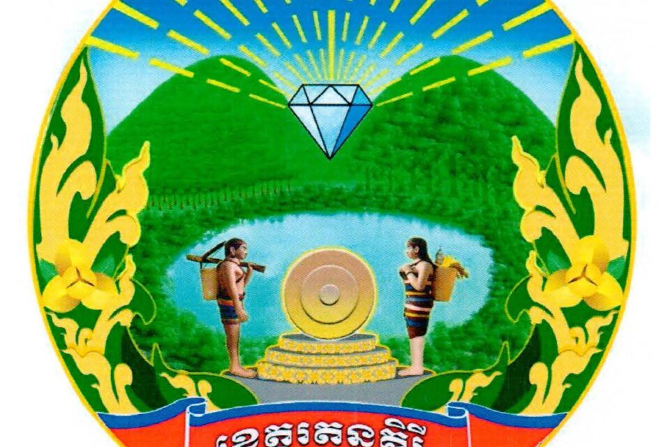
The provincial symbol is decaled by Ministry of Interior via a Prakas No.2784 BrK dated 22 June 2020 on the Establishment of Ratanakiri Province Symbol. The symbol has shape, image and color as follow:
- The shape and form of the Ratanakkiri symbol are round.
- Mountains and forests image represents the topography of Ratanakkiri province, which is rich in mountains, valleys, streams along the border with the Lao People’s Democratic Republic, the Socialist Republic of Vietnam, and in the highlands of the province. Rich in natural resources, both on land, underground and in water, as well as agricultural, agro-industrial crops of all kinds, which are important potentials for economic and social development in Ratanakkiri.
- The image of Gems represents the diversity of precious gems/stones in the territory of Ratanakkiri. And with this, the rays shining from the gems have a total of 59 wheels, representing the year of birth of Ratanakkiri province, which was established on Tuesday, February 17, 1959, signed by Samdech Preah Norodom Suramarit at the request of H.E. Pho Preung, Senior Minister in charge of the Ministry of Interior, which was removed from Stung Treng Province. The combination of precious stones and mountain forest gives meaning to the name of the province, “Ratanakiri”.
- The blue-sky water surface in the middle represents Lake Yak Laom, a historical natural lake formed by volcanic eruptions and ranked 12th most beautiful lake in the world. On the other hand, it represents the waterfalls, lakes and the two main rivers that flow through the province, the Sesan and Srepok rivers, which are the source and potential of natural resources, biodiversity and all kinds of fish.
- Men and women with back basket (Ka Pha is a famous tool which is weaving from a type of vine by indigenous people in the northest of Cambodia) and crossbow (Snaa is type of weapon made from wood, with a tiller or stock, a string, a trigger, and arrows/bolts) image represents people of all races, especially indigenous peoples of eight different ethnic groups, living and earning a living by adhering to the cultural traditions of each group in the territory of Ratanakiri province.
- The feminine gong or Kong Nhee (is a bossed gong from Ratanakiri province in northeastern Cambodia. This musical instrument is a round bronze-brass alloy plate with a round lump in the center, called Boss, consisting of a variety in size for different pitch) on the three-tier terrace in the center of the symbol represents the soul identity of all indigenous people who live and earn in daily life in Ratanakkiri province. This Gong is used to perform in various ritual events according to the indigenous traditions of the indigenous people, such as the village festival, Sen Arak or the funeral.
- The black-and-white lanterns at the bottom of the symbols represent the beautiful fine art, culture, and traditions of the indigenous peoples, who often carve these carvings on their consumables, the walls of houses, village halls, as well as souvenirs and so on.
- The yellow figurine is accentuated by a bunch of a romduol flower, which are assembled in the style of flower vines (Kbach Phni Voa), which are pointed upwards on either side of the symbol, resembling raising both hands to salute to wish for peace and prosperity for the people in the province as well as the general Cambodian people. It also represents the agricultural products in the province where many people live and make a living by relying mainly on agriculture, agro-industry to contribute the development and promotion of the family economy and society.
- Red and blue ribbons highlighted with the phrase “Ratanakiri Province” indicate the national, religious, monarchy identity of the territory-people and independence, territorial integrity and identity of Ratanakiri Province.
- Gold Color represents the wealth of light to the yield of our beloved Angkor Sovannaphum land
- Blue Color represents territorial.
- Red Color represents the nation, the territory and the people to unite as a strong will, unity, solidarity in the protection of territorial integrity and harmonious living of the people.
- Green Color represents the development, growth, beauty and conservation of green natural resources in Ratanakiri.
- Sky Blue Color represents peace.
Accessibility
Ratanakiri Province, while somewhat remote, is accessible through various means of transportation. Here are the main options for reaching the province:
- Road: The main road through Ratanakiri is National Road 6 (which starts in Phnom Penh about 588 kilometers), 7, 8, and continues to the province via National Road 73, 76, 78, 78-5, and 78C.
- Airway: Ratanakiri has one provincial airport located in Ban Lung city, called Ratanakiri provincial airport. Its runway length is 1,300 meters on laterite surface. Since the late 2000s, no commercial flights to Ban Lung are available and only chartered and private flights use the airport.
Tourism Products
Ratanakiri Province is a treasure trove of natural beauty and cultural diversity, making it an appealing destination for tourists. Here’s a more detailed look at the tourism resources available in the province:
Yeak Laom Lake (បឹងយក្សឡោម): A stunning volcanic lake surrounded by forest, ideal for swimming, picnicking, and enjoying the scenic views. Yeak Laom Lake is a natural lake, about 5 kilometers from downtown of Ban Lung. The shore of Yeak Laom Lake forms an almost perfect circle. It is 750 meters in diameter, and about 48 meters deep. Its shape and depth are due to its volcanic’s origin. The lake is encircled by a ring of forest, and the clear emerald water is used for swimming, with lifejackets provided. A 3-kilometer path circles around the lake, with a small museum offering insight into Tampuan culture. Handicraft stores selling souvenirs made by the hill tribes living nearby are found at the entrance, and ethnic costumes can be rented for photo shoots. It is located at Sangkat Yak Laom of Ban Lung city.
Virachey National Park (ឧទ្យានជាតិវីរៈជ័យ): A biodiversity hotspot featuring lush jungles, rivers, and wildlife. It offers trekking trails, birdwatching, and opportunities to explore diverse ecosystems. Located at Yeun village, Kak commune of Bar Kaev district, Virachey National Park is a national park in northeastern Cambodia covering an area of 3,380.57km2. It is home to many endangered wildlife animals and birds, such as douc langur, gibbon, wild pig, red muntjac, sambar, fishing cat, clouded leopard, gaur, bear., etc. In the deep part of the jungle, there is a waterfall called Yeakkea. In the rainy season, the waterfall is really beautiful and good for swimming.
Eisei Paktakmak Mountain (ភ្នំឥស្សីបតមៈ): Found in Phnom Svay village, Sangkat Boeng Kansaeng of Ban Lung city, Eisei Paktakmak may be a title of an old mountain God who ensured this range for a long time. Eisei is famous to identify an austere in Hinduism, but there’s too a huge Buddha statue here approximately 5m long. In early 1960s, this put kept its title as Eisei Paktakmak. Most individuals are Buddhist more so than Hindu, but this heavenly put is still adored by neighborhood individuals to ask for luckiness, fortune, and bliss. Eisei Paktakmak is the foremost effective sacred put for nearby individuals in Ratanakiri area.
Yak Nang Temple was constructed from sandstone and faces east. It was found in 2006, and it is assumed that this temple was built during the Angkor era between the 10th century and 11th century. It is located at Dor Touch village, Ya Tung commune of O Ya Dav district.
Veal Thmor Rum Plang (វាលថ្មរំប្លង់): Located in O Chum commune of O Chum district, it is a natural attraction site and its main features include huge granite terraces and a natural stream in the forest. According to a legend of the Kreung ethnic group, there once was a boy named Rum Plang who flew his kite on this terrace. Unfortunately, the kite got stuck in a tree. Rom Plong climbed the tree to retrieve his kite but fell from the tree and died. His body was buried in the forest. That is how the site came to be known as Viel Rom Plong, after the name of that boy. The site is a popular place to picnic.
7-Step Waterfall or O’Sien Lae Waterfall (ទឹកជ្រោះ៧ជាន់ ឬ អូរសិនលែរ៍): It has an amazing landscape of a waterfall and the surrounding natural environment. The water flows all year round. It is located in Village 3, Kaleng Commune, Lumphat District, Ratanakkiri Province, about 24 kilometers from the Independence Monument in Ban Lung City.
Cha Ong Waterfall(ទឹកជ្រោះចាអ៊ុង): Flow from Phnom Svay near Ban Lung city, it is 25m high, surrounded by vines and numerous plants and trees that provide shade. The scenery is breathtaking, and the water vapor collides with the forest, forming the rainbow in the sunlight. It is located in Phnom Kreung tribe village, Cha Ong village, Cha Ong commune of O Chum district.
Kachanh waterfall (ទឹកជ្រោះ កាចាញ): Located in Kachanh village, Sangkat Kachanh of Ban Lung city, it is a natural attraction site that has a rich, green landscape, a beautiful waterfall, and a refreshing and cooling environment. This waterfall can attract crowds of visitors to enjoy swimming, crossing the swing bridge, seeing the mountain and forest views, and having picnics.
Boeung Lum Kud (បឹងលំកុដ): it is a natural lake that its mouth is shaped like a human heart. The lake is 25 hectares in size, about 60 meters deep, and has the same ecological characteristics as Yeak Laom Lake. It also forms from the ancient volcano eruption as Yeak Laom lake. Located in the highlands and mountain ranges covered by evergreen tropical forests, Boeung Lomkot has sloping trees. Many seem to fall to the surface of the clear blue lake, and naturally the water is cooler than other lakes.
Ka Teang Waterfall (ទឹកធ្លាក់កាទៀង): it is located in Ka Teang Village, Lbang 2 Commune, Lumphat District, about 9 km from Banlung City, Ratanakkiri Province. Before heading to Kachan Waterfall Resort, there is a detour to the right along the fence of a factory to the south is the road to the Ka Teang waterfall resort, which is only 3 km away. This resort is located in the middle of the mountain forest with big trees that can provide cool shade to tourists. To appreciate the beautiful scenery of this waterfall more strangely, you have to go down via wooden stairs. Behind the waterfall there is a large cave that allows visitors to enter and see the scenery of rushing waters. At the top, near the waterfall, there is an elephant ride for a trekking in the forest. There are many handicrafts made by the Kreung people on display, such as gourds, crossbow, gongs, and indigenous skirts, etc.
Tat Tay Water Rapid (ទឹកជួរតាតតៃ): About 34 kilometers from downtown Ban Lung, it is a natural attraction site located in Kaleng commune of Lumphat district, which features a rock cascading water along the Srepok River. This place is very attractive during the dry season from February to April. During these months, tourists can swim in the clear, rapid water and there is also a flooded forest.
Ratanakiri has a diverse array of tourism service providers that cater to the needs of visitors, offering everything from guided tours and transportation to accommodation and dining. Below is an overview of the main types of tourism service providers in the province:
Accommodation: Eco-lodges and Homestays, various eco-lodges and homestays offer comfortable accommodations while promoting sustainable tourism practices. Staying with local families provides an authentic cultural experience. Resorts and Guesthouses: A range of accommodations, from budget guesthouses to more upscale resorts, are available in Ban Lung city and other parts of the province. There are 13 places of resorts, hotels, Bungalows, equally 505 rooms and Guesthouse is 32 places (379 rooms).
Restaurants and Eateries: Local Restaurants and Cafés offer a variety of Cambodian dishes, including regional specialties. Moreover, Street Food offers an authentic way to experience local cuisine, with vendors selling snacks and meals at markets and along the streets. There are 38 restaurants and eateries (equally to 934 chairs).
Transportation Services: Several bus companies operate services from Phnom Penh, Siem Reap, and other major cities to Ban Lung, the provincial capital of Ratanakiri. The journey typically takes around 8-10 hours from Phnom Penh and about 12 hours from Siem Reap, depending on road conditions. Renting a car or hiring a taxi can offer more flexibility and comfort. The road conditions vary, but significant improvements have been made in recent years. Local transport options include tuk-tuks, motorbike rentals, and buses, making it easier for visitors to explore the region. Once in Ban Lung, local tuk-tuks and motorbike rentals are available for exploring the province and accessing tourist attractions. Shared taxis or minivans can be a convenient way to travel between towns and attractions within the province. Some roads, especially during the rainy season, may be less accessible, leading to potential delays or detours. It’s advisable to check local conditions and plan accordingly. While Ban Lung has basic amenities, more remote areas may have limited facilities, so it’s important to be prepared for a more rustic travel experience.
Ratanakiri Province is rich in natural resources and cultural heritage, offering a unique blend of adventure, relaxation, and cultural immersion. With its diverse attractions, it caters to a wide range of interests, making it a captivating destination for travelers seeking to explore the less-traveled paths of Cambodia.
Gallery
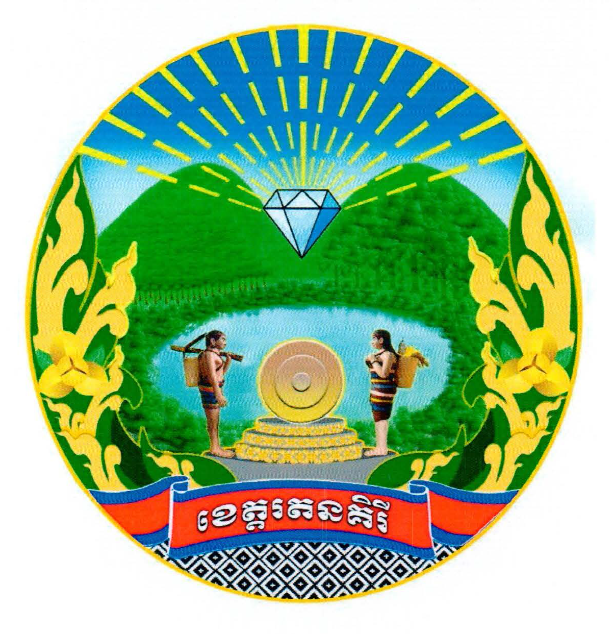 Logo of Ratanakiri province
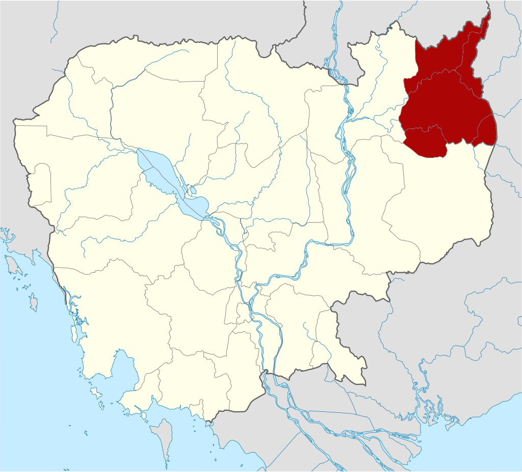 Map of Ratanakiri © Kmusser
