Kampong Thom Province
Kampong Thom is a central province of Cambodia that is 168 kilometers from Phnom Penh and 150 kilometers from Siem Reap along National Road 6. Kampong Thom, covering 13,814 square kilometers, borders (from north clockwise) Preah Vihear, Stung Treng, Kratié, Kampong Cham, Kampong Chhnang, Tonle Sap lake, and Siem Reap.
Kampong Thom is divided into 08 administrative districts and 1 municipality, Stung Saen City. With over 700,000 people, the province is Cambodia’s second largest area and eleventh most populous. Kampong Thom is a significant province historically, where many historical structures, artifacts, and prehistoric settlements have been discovered including the Group of Prasat Sambo Prei Kuk temples and Prasat Andet temples. Moreover, this province is also home to two of the three core areas in Tonle Sap Biosphere Reserve.
History
Kampong Thom, a central province of Cambodia, has a history mirror much of Cambodian’s broader historical trajectory, characterized by ancient glory, colonial influence, and modern challenges.
Pre-History or Early History Period
The area of Kampong Thom held an important position in early Khmer History (Pre-Angkor Period) from the late Funan (68 to 550 A.D.) to Chenla (550 to 802 A.D.) period, some of the earliest known civilizations in Southeast Asia. Chenla or Zenla was a former vassal of the Funan Kingdom (Norkor Phnom or the Mountain Kingdom). Later, Chenla progressively gained its supremacy and ultimately proclaimed its independence from having conquered the Funan Kingdom by King Citrasena Mahendravarman in the late 6th century. Historically, the area near the Stung Saen river was the ancient capital to Chenla or Zenla Kingdom roughly in the late 6th century to the early 7th century, called Isanapura or Sambor Prei Kuk, and is noted for its unique architectural style that predates the Angkorian period. The name Isanapura, literally means “Isana Castle”, also appears in Chinese Historical Literature such as The Great Tang Records on the Western Regions, a travel and topographical records by a Tang Buddhist monk called Xuanzangs, contains indication of Isanapura as one of the six South Sea states signifying that the affluence of Chenla or Zenla Empire extended to foreign countries, and the Book of Sui holds a predominantly descriptive passage and provides an early record of Isanapura in the first half of the 7th century. Chinese historical records dealing with Isanapura, Book of Sui, gives more detailed description of the city that there were about 20,000 houses located in and around the city, by way of explanation, an expected population of nearly 100,000 in the early 7th century. During the height of the Khmer Empire (9th to 15th centuries), Kampong Thom continued to be an important region. It was strategically located along the ancient royal road connecting the Angkor capital with other significant provincial centers. After the decline of the Angkor Empire in the 15th century, the region experienced periods of instability and was often contested by neighboring kingdoms, including the Siamese and Vietnamese.
Colonial Period
In the 19th century, Cambodia became a protectorate of France. The French administrated and divided Cambodian territory into provinces, and named most of them according to the spoken words of local people for the respective areas. For instance, Kampong Thom was one of them when it was assigned to be provincial status in 1907. The French influence led to significant changes in the administrative and social structures of the province. Kampong Thom Province during the reign of King Sisowath Monivong (1927-1941) was divided into the following districts and regions: Chao Vai Khet “ចៅហ្វាយខេត្ត” (Provincial Governor):
- Oknha Techo Bora Reachtharanin Rin Borirak Samuha Thipadei Aphai Bara Udomkrampahu “ឧកញ៉ាតេជោបូរារាជធរណិន្ទរិន្ទបរិរក្សសមុហាធិបតីអភ័យបារាឧត្ដមក្រមពាហុ”
- Phu Chuy Khet “ភូឈួយខេត្ត” (Vice Provincial Governor): Techo Anichit “តេជោអនិជិត”
- Ballat Khet “បាឡាត់ខេត្ត”: Sneha Techo “ស្នេហាតេជោ”
- Chao Vai Srok Kampong Svay “ចៅហ្វាយស្រុកកំពង់ស្វាយ” (Governor of Kampong Svay District): Sena Techo “សេនាតេជោ”
- Ballat Srok Kampong Svay “បាឡាត់ស្រុកកំពង់ស្វាយ” (Ballat of Kampong Svay District): Metrei Techo “មេត្រីតេជោ”
- Chao Vai Srok Sandan “ចៅហ្វាយស្រុកសណ្ដាន់” (Governor of Sandan District): Vornea Pheak “វនាភក្ដិ”
- Chao Dambon Sdang “ចៅតំបន់ស្តង់” (Governor of Sdang Region): Damrong Rithy Chey “ដំរង់ឫទ្ធិជ័យ”
- Chao Vai Srok Prom Tep “ចៅហ្វាយស្រុកព្រំទេព” (Governor of Prom Tep District): Tep Pheakdey Techo “ទេពភក្ដីតេជោ”
- Chao Vai Srok Baray “ចៅហ្វាយស្រុកបារាយណ៍” (Governor of Baray District): Saen Khang Pha “សែនខាងហ្វា”
- Ballat Srok Baray “បាឡាត់ស្រុកបារាយណ៍” (Ballat of Baray District): Pheakdey Khang Pha “ភក្ដីខាងហ្វា”
- Chao Vai Srok Storng “ចៅហ្វាយស្រុកស្ទោង” (Governor of Storng District): Muntrei Techo “មន្ត្រីតេជោ”
- Chao Vai Srok Santuk “ចៅហ្វាយស្រុកសន្ទុក” (Governor of Santuk District): Sotip Muntrei “សុទិព្វមន្ត្រី”
- Ballat Srok Santuk “បាឡាត់ស្រុកសន្ទុក” (Ballat of Santuk District): Muntrei Sotep “មន្ត្រីសុទេព”
- Chao Dambon Boeung Lvea “ចៅតំបន់បឹងល្វា” (Governor of Boeung Lvea Region): Tep Sena Techo “ទេពសេនាតេជោ”
Independence and Conflict Period
Cambodia gained independence from France in 1953. However, the country soon faced internal strife, culminating in the Cambodian Civil War and the rise of the Khmer Rouge. Kampong Thom was heavily affected during the Khmer Rouge regime (1975-1979), with widespread atrocities committed against the local population. After the fall of the Khmer Rouge, Kampong Thom began the slow process of recovery and rebuilding. The province remains largely rural, with agriculture being the mainstay of its economy.
Modern Day
Kampong Thom is known for its rich cultural heritage, with numerous temples and historical sites. The ancient capital of Isanapura, presently known as the Temple Zone of Sambo Prei Kuk-Archaeological Site of Ancient Isanapura which inscribed in the UNESCO World Heritage Site in 2017, are covered in the vast are of more than 6 kilometers in an East-West direction and 4 kilometers in a North-South direction which contains 7 villages. This archaeological site can be largely divided into two major zones: the western city zone and the eastern temple zone delineated by O Krou Ke stream.
Kampong Thom is one of five provinces which shared boarder with the Great Lake (Tonle Sap Lake). The area of the province is divided into two parts: The Eastern part and Western part of National Road 6. The Eastern part covers about 70% surface comprising of forests and plateaus that are lavish in natural resources for a good and profitable agriculture, forestry and animal husbandry. The Western part, on the other hand, covers 30% of surface comprising of flood-plain area extending to the Great Lake that is one of the finest areas in the Kingdom for rice cultivation and fishing to sustenance the needs of the province and to additionally export to other areas or abroad. Moreover, the province is homed to two of the three core areas in Tonle Sap Biosphere Reserve such as Boeng Chhmar (14,560 hectares) and Stung Saen (6,355 hectares). Therefore, it remains one of Cambodia's key provinces, contributing significantly to the country's economy and cultural identity.
Dignitaries who were former governors of Kampong Thom since 1979
There were 13 Governors of Kampong Thom Province from 1979-Present, including:
Kampuchea (People’s Republic)
- H.E. Ros Chhun (ឯកឧត្តម រស់ ឈុន) 1979-1982
- H.E. Ngoun Nhil (ឯកឧត្តម ងួន ញិល) 1982-1984
- H.E. Sou Han (ឯកឧត្តម សូ ហាន់) 1984-1985
- H.E. Khiev Horl (ឯកឧត្តម ខៀល ហ៊ល) 1985-1988
- H.E. Un Nueng (ឯកឧត្តម អ៊ុន នឹង) 1988-1990
Kingdom of Cambodia
- H.E. Chieng Um (ឯកឧត្តម ជៀង អំ) 1990-1998
- H.E. Nou Phoueng (ឯកឧត្តម នូ ភឿង) 1998-2003
- H.E. Naim Tum (ឯកឧត្តម ណាំ ទុំ) 2003-2009
- H.E. Chhun Chhoan (ឯកឧត្តម ឈុនឈន់) 2009-2013
- H.E. Uth Sam An (ឯកឧត្តម អ៊ុត សំអន) 2013-2016
- H.E. Sok Lu (ឯកឧត្តម សុក លូ) 2016-2019
- H.E. Ngoun Ratanak (ឯកឧត្តម ងួន រតនៈ) 2019-2024
- H.E. Noun Pharoth (ឯកឧត្តម នួន ផារ័ត្ន) 08 July 2024-Present
Geography
Kampong Thom Province is situated between latitudes 12.42° North and longitudes 104. 53°.The province’s geography is marked by its central plains, significant water bodies, and forested regions, making it a significant area both geographically and economically. Here's an overview of its geography:
Topography: The majority of Kampong Thom consists of low-lying plains that are part of the larger Cambodian central plains. These fertile areas are primarily used for rice cultivation and other agricultural activities. Additionally, the province also features parts of the Dangrek Mountain range to the north and the Cardamom Mountains to the southwest. These areas are less populated and more forested, contributing to biodiversity.
Water Bodies: Although Kampong Thom does not directly border the Tonle Sap Lake, its western regions are part of the Tonle Sap basin. The lake's annual flooding significantly influences the province's agriculture and fishing industries (freshwater fishery and freshwater aquaculture i.e. Crocodile Farms). Furthermore, Stung Sen River is One of the major rivers in the province, the Stung Sen River, flows through the central part of Kampong Thom and into the Tonle Sap Lake. The river provides water for irrigation and supports local ecosystems. Beside Stung Sen River, Kampong Thom has other three major rivers such as Stung Stoung, Stung Chi Nith, and Stung Taing Krasaing.
Climate: Kampong Thom experiences a tropical monsoon climate, characterized by a wet season from May to October and a dry season from November to April. The province receives ample rainfall, particularly during the wet season, which is crucial for its agricultural productivity. Temperatures are generally warm throughout the year, with average highs ranging from 30°C to 35°C (86°F to 95°F) and average lows from 20°C to 25°C (68°F to 77°F).
Vegetation and Land Use: The fertile plains of Kampong Thom make it one of the significant rice-producing areas in Cambodia. Other crops such as rubber, cashew, acacia (eucalyptus), mung bean, soybean, sesame, hollyhock, maize, cassava, sweet potato, pepper, watermelon, and various vegetables; fruits or orchard (mango, orange, dragon fruit, durian); Horticulture are also cultivated. The province has significant forested areas, especially in the northern and southwestern parts. These forests are home to diverse flora and fauna and are crucial for maintaining ecological balance. Especially, Kampong Thom includes parts of the Prey Lang Wildlife Sanctuary, one of the largest remaining lowland evergreen forests in Southeast Asia. This area is critical for biodiversity conservation and is home to many endangered species.
- Boeung Per Wildlife Sanctuary covered land area of 242,500 hectares (this is the total area of Boeung Per Wildlife Sanctuary sharing with Preah Vihear and Siem Reap Provinces)
- Prey Lang Wildlife Sanctuary is covered an area of 489,663 hectares, sharing with Kratié, Stung Treng, and Preah Vihear.
- Tonle Sap Lake Multiple Land Use covered area of 316,250 hectares (this is the total area sharing with Kampong Chhnang, Battambang, Pursat, and Siem Reap Provinces)
Administrative divisions
As of 2024, the province is divided into 1 municipality (Krong) and 08 districts (Srok), 08 Sangkat and 73 communes (Khum), and 765 villages. Based on 2022 census, the total population is 844,044 people (female 427,630), the number of indigenous “Kuy” families are 3,284 (equally 14,767 people), and the density is 54.55 people/km2. The population of the province is predominantly rural, with many small villages and towns spread throughout. The population relies heavily on agriculture, fishing, and forestry for their livelihoods. Stung Saen municipality is the seat of government, commonly known Krong Stung Saen or Stung Saen City, which is located along National Highway 6, connecting Phnom Penh to Siem Reap.
- Stung Saen Municipality (08 Sangkat)
- Baray District (10 Khum)
- Kampong Svay District (11 Khum)
- Ballangk District (7 Khum)
- Prasat sambour District (5 Khum)
- Sandan District (9 Khum)
- Santuk District (10 Khum)
- Stoung District (13 Khum)
- Taing Kouk District (8 Khum)
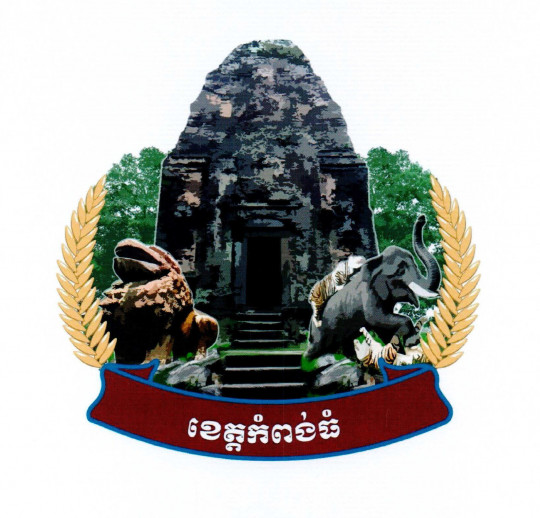
The provincial symbol is declared by the Ministry of Interior via a Prakas No.2107 BrK dated 1 April 2019 on the Establishment of Kampong Thom Province Symbol. In this symbol, there are five images, such as:
- Central Tower of Yeay Poan temple image (Southern Group of Sambo Prei Kuk temple Zone) represents the splendor of Khmer architecture in the 7th century which is located in the Temple Zone of Sambo Prei Kuk, Kampong Thom province, and the ancient Khmer belief in Hinduism.
- Lion Statue image (from the Lion Temple of Sambo Prei Kuk Temple Zone) symbolizes the Greatest of Khmer art in the late Chenla period and embodies the mighty power to protect against all evil, as the lion is the King of mammals.
- Tiger-Elephant fighting image signifies the Kampong Thom province that dates back to the 1960s and reflects the realities of its natural resources and also represents the scene in the epic poem of Reamker (Khmer Version of Ramayana).
- Rice Husk image represents the richness and prosperity of the agricultural sector, especially the yield of rice in Kampong Thom.
- Trees represent the growth of the agro-industry which the province is rich in fertile land and in favor of agricultural and agro-industrial crops.
While the ribbon below has the written letters of Kampong Thom with a dark red background representing the color of culture to show that Kampong Thom is a province of culture as well.
Accessibility
- Road: The main road through Kampong Thom is National Road 6, which starts in Phnom Penh (168 kilometers). Traveler can access to the province via National Road 6 from Siem Reap (150 kilometers) as well. Major transportation routes, such as National Highway 6, facilitate connectivity with other parts of Cambodia. The infrastructure is gradually improving, with ongoing development projects aimed at boosting the local economy and accessibility.
- Waterway: Kampong Thom can access by river cruise from Phnom Penh via Tonle Sap River and Tonle Sap Lake. However, it is not so popular among the travelers both local and international.
Tourism Products
Kampong Thom, a province in central Cambodia, has a growing tourism sector characterized by its rich historical sites, natural beauty, and cultural heritage. Key attractions and features include:
The Temple Zone of Sambo Prei Kuk-Archaeological Site of Ancient Isanapura (តំបន់ប្រាសាទសំបូរព្រៃគុហ៍-តំបន់បុរាណវិទ្យានៃរាជធានីឦសានបុរៈ): This ancient archaeological site is a pre-Angkorian temple complex, designated as a UNESCO World Heritage Site in 2017. It consists of numerous temples and structures dating back to the Chenla Kingdom in the 7th century.
Andet temples (ប្រាសាទអណ្តែត): Andet Temple is one of the many brick temples in Prasat Andet village, Sunkor commune, Kampong Svay district, Kampong Thom province and is a site where many people visit, particularly during Khmer New Year and other holidays. This Hinduism temple in Prey Khmeng Style is made of brick, with masonry, laterite, and sandstone, and is considered by many archaeologists to be an ancient Khmer cultural site built in the pre-Angkorian period of Jayavarman I, approximately in the second half of 7th century (627-707 A.D) and dedicated to Hirihara (Shiva-Vishnu). Faced to the east, the temple is isolated plan with 5.3 meters built on a mound, was form in rectangular shape with 7.5 meter-length, 5.5 meter-width, and 1 meter-thick (interior to exterior). The coronet (2.22 lengths) was ornamated around by the rings, and in between the rings decorated with garland and bulb flowers in rounded, which are joining each other by the end of the decorations. Formerly, this temple contained Standing Harihara Statue on a decorative royal throne, and the statue was brought to be displayed at Phnom Penh National Museum. There is a framed door with 1 meter-width, 2 meter-height and 0.2 meter-thick.
Kuk Nokor temple (ប្រាសាទគុកនគរ): the temple was built on the flat ground, made of the laterite stone and sandstone, and features a square courtyard and two ponds built in the Khleang style in the 10th-11th century, during the reign of King Suryavarman I (1002-1050). Facing to the east, the temple is dedicated to Hinduism and the entire temple is protected by a laterite embankment that stretches from the west to the east (a 35-meter length) and north to the south (a 25-meter width). This embankment (rampart) has one meter height and 0.8 meter thick with two entrances or gateways (Gopura): Eastern gateway is 9 meters height divided into 3 rooms, and western gateway is small and has square shape. East of the temple, there are 2 ponds: the small one has about 3-meter depth, 45-meter length and 20-meter width, and the big one has 160-meter length, 88-meter width and more than one meter depth. The site also has a modern Buddhist pagoda located behind the temple, with beautiful views and fresh air. In particular, international tourists can come to see exemplary examples of a modern pagoda with ancient decorations, such as the Naga skin roof tiles. This temple is located in Trodock Poong village, PongRor commune, Taing Kouk district, approximately 79 kilometers from Stung Sen town and turn right about 2 kilometers.
Prasat Kok Rokar or Preah Theat Temple (ប្រាសាទគោករការ ឬប្រាសាទព្រះធាតុ): the temple is located in Rokar village, Sangkat Srar Yov of Stung Sen town about 14 kilometers from the downtown area. The temple was built of sandstone and laterite in Khlean Style at the end of 11th century during the reign of King Suryavarman I to dedicate to Shiva God. This isolated sanctuary (dimension: 6 meters by 5 meters; 8-meter height) was built on the mound and faced to the east. The central part of the temple has conical form (ទម្រង់ជាសាជី) with porches (រានហាល) opening to the east, and a door reached from the eastern entrance (three other doors were the false doors). The colonnette has octagonal forms, and the three lintels have various forms. Based on the study to the site, the sanctuary was formed in rectangular shape. The outside rampart has 25 meters * 25 meters in size and Gopura from the four directions which joined to the surrounding laterite rampart. Outside the rampart, there were likely moat surrounded as we saw some marks remain until now.
Kroul Romeas Temple (ប្រាសាទក្រោលរមាស): located at the southern side of Sambor Group about 500 meters, this temple was built during the reign of King Suryavarman I (end of 11th century). The temple made of brick, sandstone and laterite and dedicated to Shiva God. At the eastern temple there were four small brick sanctuaries, arranged in line on quadrilateral mound and faced to the East, probably built later Sambor temple group. At the southern of these temples, there were two temples recognized as the original ancient Khmer styles and these temples were very important other temples in that area. Within Kroul Romeas temple group situated in the southeastern, there is a temple called Srei Kroupleak temple.
Sandan Temple “ប្រាសាទសណ្តាន់”: this temple group is located in the western part of Sambor Group, Tor Group, and Yeay Paon Group. This temple group contain the scatter more sanctuaries and there is a way from one to another temple. Each temple is distance about 50 meters to 300 meters from each other such as: Bos Ream Temple, Asram Eisey Temple, Chrey Temple, Chambak Temple.
Chrei Temple (ប្រាសាទជ្រៃ) is a potential historical and cultural site located in the archaeological Sambo Prey Kuk complex, built during the pre-Angkorian era, about the 7th century, during the reign of King Isanavarman I (616-637 CE) or early the reign of King Bhavarman II (637-651 CE). The temple was built by sandstone and mainly brick, and is dedicated to the Hindu god Shiva, named Çrīratneçvara. This temple is special in that it is covered by the roots of oak trees in a spectacular manner.
Pur Thi Vaing Temple or Kuk Vaing Temple (ប្រាសាទពោធិវាំង ឬប្រាសាទគុកវាំង): The temple is located in Pur Thi Vaing monastery, Vaing Tboung village, Taing Krasang commune of Santuk district. This standalone temple built of brick in the Kampong Preah or Prey Khmeng style of late Chenla period and it dedicated to Shiva.
Thnoat Chum Temple (ប្រាសាទត្នោតជុំ): Located in Thnoat Chum village, Thnoat Chum commune of Baray district, this temple consists of two sanctuaries, the first is the West Kuk temple and the second is north Kuk temple (Kuk Kambot). This temple was built by Sambor Prei Kuk style in 7th century.
Phumi Prasat Temple (ប្រាសាទភូមិប្រាសាទ): This temple is located in Prasat village, Prasat commune of Santuk district, about 29 kilometers from provincial town and there is road from the southern direction of 500-meter length. This temple was built brick, masonry (កំបោរបាយអរ) and sandstone in 8th century (706 A.D.) during Queen Jayadevi with Kampong Preah Style and dedicated to Shiva god. The temple has a sanctuary (តួប៉មប្រាសាទ) built on the flat terrace without the false door (ទ្វារបញ្ឆោត) and faced to the east. In the ancient period, the door was made by two wooden boards-one carved with figures of male divinities at another one carved with female divinities. The southern framed door was inscribed with five lines of inscription, and its back was mostly eroded. The lintel was ornamented by the garlands (កម្រងផ្កាផ្ញី); colonnette (សសរពេជ្រ) and the upper corner of the temple by contained the segments of Linga and Yoni. South of the large temple, was a mound called Toul Samroung or Toul Nak Ta Samroung; and east of this mound, three was a Po tree (Bayan Tree) in which local people call Toul Nak Ta Deum Po.
Tonle Sap Lake (បឹងទន្លេសាប): The largest freshwater lake in Southeast Asia, Tonle Sap is a critical ecological zone and a major attraction for those interested in nature and traditional Cambodian life. The lake is known for its floating villages and abundant birdlife. Moreover, this province also homes to two of the three core areas in Tonle Sap Biosphere Reserve (a UNESCO Biosphere Reserve).
Stung Chinith Resort (រមណីយដ្ឋានស្ទឹងជីនិត): it is a natural man-made resort located at the border of Baray and Santuk district about 37 kilometers from provincial town, when arriving Kampong Thmar market town turn left to national road 71 about 3.7 kilometers, then turn left on dirt road about 600 meters along the canal to Stung Chinith. This area is a Stung Chinith hydraulic system constructed in 1976 during Pol Pot regime. In 2008, Kampong Thom Authority has cooperated with Ministry of Tourism established to be tourism site for attracting tourists with developing various tourism industry and infrastructures.
Stung Prei Pros Resort “រមណីយដ្ឋានស្ទឹងព្រៃប្រស់”: it is a natural man-made resort located at Prei Priel village, Preal commune of Kampong Svay district about 16 kilometers on the both side of national road 6. This resort is popularity place for national and international tourists when they traveled across this region to rest with fresh air and having meal with lake and rice field view.
Indrisamvora Pagoda or Wat Kampong Thom (វត្តឥន្ទ្រីយ៍សំវរៈ ឬវត្តកំពង់ធំ): Located in Kdey village, Sangkat Prey Ta Huo of Stung Sen town, the pagoda was built in 17th century by Oknha Techo Boran Reachea Theani Meas, called Ta Krahamka (ឧកញ៉ាតេជោបុរាណរាជធានីមាស ហៅតាក្រហមក). This pagoda was selected for tourism attraction, because it is better criteria such as: beautiful, good environment, sanitation, large place, different gateways and architectural buildings constructed in Khmer Style and there are infrastructures like Pali Building, library, monastery, monk’s quarters, Sala Chhan (Cafeteria for monks), and displaying the roofless ox cart (រទេះសាឡី), palm boat etc. This pagoda is also the holy place, education site of both Buddhist laws and Man-made laws (ពុទ្ធចក្រ និងអាណាចក្រ), and the visitation area during the traditional festival.
Kampong Thom Museum (សារៈមន្ទីរខេត្តកំពង់ធំ): Located along national road 6 in Acha Lak village, Sangkat Acha Lak of Stung Seng city, about 3 kilometers from the provincial town, it was constructed in 2008 and inaugurated on the 11 January 2010. With 21 meters in length and 11 meters in width, the museum can allow visitors to be more attentive of Khmer culture and historical value. Khmer arts have been exhibited since ancient time including sculpture statues, Pdae (the part of a Khmer house which joins the roof to the wall), fronton (ហោងជាង), lintel (ធ្នឹម), Linga, Yoni, ceramics (កុលាលភាជន៍) and inscription etc.
Phnom Santuk (ភ្នំសន្ទុក): A significant religious site with a series of temples and Buddha statues on a hilltop, offering panoramic views of the surrounding countryside. The climb to the top is a popular activity for both pilgrims and tourists. It is a cultural and natural site located in Ko Koh village, Ko Koh commune of Santuk district, about 15 kilometers from the Stung Sen city along National Road 6 and turn left 2 kilometers. The site has been called in many names as followings: Phnom Thom “ភ្នំធំ” (in history), Phnom Santuk “ភ្នំសន្ទុក” (in history), Phnom Kroptuk “ភ្នំគ្របទុក”, Phnom Arth Santuk “ភ្នំអាថ៌សន្ទុក” (in history), Phnom Chorm Chong Kiri “ភ្នំចមចុងគិរី”, Phnom Preah Bat Chointuk “ភ្នំព្រះបាទជាន់ទុក”. This site area has been four mountains: Phnom Santuk, Phnom Sras Khchao “ភ្នំស្រះខ្ចៅ” (Phnom Tbeng “ភ្នំត្បែង”), Phnom Penchum “ភ្នំពែនជុំ” (Phnom Krarpeur “ភ្នំក្រពើ”), and Phnom Champa “ភ្នំចម្ប៉ា” (Phnom Srouch “ភ្នំស្រួច”). This site is rich in cultural resources such as:
- By the stories, the construction and the statues were erected during the reign of Preah Ponhea Dharma Reachea (1474-1494)
- Staircase climb up to the top of the mountain, 2.8-meter width and 809 steps reconstructed in 1994 on the old staircase made from concrete, 1.8 meter and 1,550 steps constructed in 1965.
- Stupa was built in 15th century and other sculptures
- Buddhist temple having eight corners constructed in 19th-20th century
- Statue of Preah Ratanakodth Preah Bat Norodom Sihanouk (ព្រះបរមរូបព្រះរតនៈកោដ្ឋព្រះបាទនរោត្តមសីហនុ).
- Many Buddha statues were carved from great mountain rock including three big Buddha image include the Reclining Buddha, each has more more than 10-meter length.
- Preah Bart Choin Tuk statue was carved on the stone shape as foot of a scared human and other sculptures.
- Prasat Touch of Pyramid shape, made of sandstone, has three stories and three-meter height, and is located next to the ancient wooden temple (presently, it is made of concrete) with a rectangular pond (10 meter * 10 meter)
Kampong Thom province offers a variety of tourism services to cater to visitors, enhancing their experience and making it easier to explore the area's attractions. Key tourism services in the province include:
Accommodations: 8 Hotels (equally 358 rooms) and 65 Guesthouses (equally 890 rooms) offer service ranging from budget to mid-range options, accommodations are available in Kampong Thom town and near popular tourist sites like Sambor Prei Kuk. Moreover, Homestays is also available, allowing tourists to stay with local families provides an immersive cultural experience and supports the local economy.
Restaurants and Eateries: Local Restaurants and Cafés offer a variety of Cambodian dishes, including regional specialties. Moreover, Street Food offers an authentic way to experience local cuisine, with vendors selling snacks and meals at markets and along the streets.
Transportation Services: Local transpiration options, including auto-rickshaw and manual-rickshaw and Moto-taxis, are common and affordable modes of transport for short distances and local travel. Moreover, Car and Bike Rentals are also available for those who prefer to explore the province at their own pace. Additionally, regular bus services connect Kampong Thom to major cities like Phnom Penh and Siem Reap.
Other Activities:
- Guided Tours includes Historical and Cultural Tours (Local guides offer tours of Sambor Prei Kuk, Phnom Santuk, and other significant sites, providing valuable insights into the history and culture of the region); Eco-Tours (Guided nature tours, including bird watching and exploring Tonle Sap Lake and its floating villages)
- Recreational Activities such as Trekking and Hiking (Organized treks to natural sites and through rural landscapes); Boat Tours (Especially popular on Tonle Sap Lake, providing scenic views and insights into the lives of people in the floating villages)
- Local Culture: Visitors can explore local villages to experience traditional Cambodian culture, crafts, and cuisine. Kampong Thom is known for its friendly locals and vibrant markets.
- Adventure Tourism: The province offers opportunities for eco-tourism and adventure activities such as trekking, bird watching, and exploring the lush landscapes and wildlife of the region.


