Mondulkiri Province
Mondulkiri is one of the northeastern provinces of Cambodia which is 382 kilometers (The provincial capital is Sen Monorom which is located in the southeastern part of the province) from Phnom Penh along National Road 7, 8, and 76.
The province has an area of 14,288 square kilometers, bordering on the west by Kratié province, on the northwest and on the north by Stung Treng and Ratanakiri respectively, and on the sound and east by the Socialist Republic of Vietnam. The naming of Mondulkiri (Mondul = Area; Kiri = Mountain) is related to the special topography of the province, which is featured by mountains, plateaus, waterfalls and valleys.
Mondulkiri is divided into 04 administrative districts and 1 municipality, Sen Monorom City. With over 84,000 people, the province is Cambodia’s largest area and also most sparsely populated province (rank 23rd). Eighty percent of Mondulkiri’s population is made up of town tribal minorities, with the majority of them being Phnong, and the remain 20 percent are Khmer, Chinese and Cham Muslims.
Mondulkiri has a high natural destiny due to good weather conditions, attractive views and landscapes, including waterfalls, mountain range, valleys, streams, green meadows stretching on the mountain top, fresh air, Sre Pok River on the border of Mondulkiri Province, mineral resources, forests, wildlife of the five wildlife sanctuaries, etc. All of these resources are the potential for the development of natural tourism and ecotourism, which are unique from other regions in the country and other countries in the region.
At the same time, Mondulkiri is also rich in cultural diversity of indigenous people, traditional dances, ethnic traditions, cultural events, handicrafts, local cuisines, nomadic plantations and elephants’ tours that are the resources and potentials for the development of cultural tourism, especially community-based indigenous tourism.
History
Mondulkiri, a province in eastern Cambodia, is known for its mountainous terrain, rich natural resources, and diverse ethnic communities, including the Bunong people. Here's a brief overview of its history:
Pre-History or Early History Period
The area has been inhabited for centuries by indigenous peoples, particularly the Bunong (Phnong) people, who have maintained their unique culture and traditions. White (1996) mentioned that the Bunong (Phnong) people in Mondulkiri are Austro-Asian and belong to the Mon-Khmer language branch, which has been settled in the area for more than 2,000 years and has been isolated for centuries. The Bunong (Phnong) are herdsmen and have nomadic farming systems based on deforestation and forest fires, which can be said to depend on the forest ecosystem as the core.
There is no much evidence of Mondulkiri's history dates back to the Funan, Chenla, and Khmer Empire period. But it could be said that the area of present day Mondulkiri has significant to each period of Cambodia Early history. During the Funan era (1st to 6th centuries), Mondulkiri province in present-day Cambodia was part of the ancient Southeast Asian kingdom of Funan. Funan was a powerful maritime state that exerted considerable influence over a wide region, including parts of modern-day Cambodia, Vietnam, Thailand, and Laos. Mondulkiri, located in the northeastern part of Cambodia, is characterized by its highlands and dense forests. During the Funan era, it would have been part of the inland regions, possibly involved in trade routes that connected the coastal cities to the interior. The area likely contributed to the kingdom's economy through the exchange of goods such as forest products, minerals, and possibly livestock. Funan was known for its extensive trade networks, both overland and maritime, and Mondulkiri's natural resources would have been valuable to the kingdom. The region's connection to trade routes would have facilitated the exchange of goods, culture, and ideas, helping to integrate it into the broader Funan civilization. However, detailed historical records specific to Mondulkiri during this period are scarce, making it challenging to provide a comprehensive account of its role and significance within the Funan kingdom.
During the Chenla era (approximately the 6th to 9th centuries), Mondulkiri province in present-day Cambodia was part of the Chenla kingdom, which succeeded Funan. Chenla was initially a vassal state under Funan but eventually gained independence and became a dominant power in the region. Mondulkiri, with its highlands and dense forests, would have been an important part of Chenla's inland territory. The Chenla kingdom is often divided into two phases: Land Chenla and Water Chenla. Land Chenla, with its capital likely located in what is now northern Cambodia and southern Laos, was more focused on inland activities and agriculture. Mondulkiri would have been part of this phase, contributing to the kingdom's resources through its natural wealth. During the Chenla era, the region might have seen increased development in terms of settlement and agricultural practices. The area's forests and highlands could have provided timber, resin, and other forest products, while its rivers and streams supported agriculture and trade. As Chenla expanded and consolidated power, the integration of regions like Mondulkiri into the kingdom would have been essential for its economic and political stability. Chenla's influence extended through complex networks of trade and cultural exchange, with routes likely passing through or near Mondulkiri, connecting it to other parts of the kingdom and beyond. However, like the Funan era, detailed historical records specific to Mondulkiri during the Chenla period are limited, making it difficult to provide a detailed account of its role and significance.
During the Khmer Empire (9th to 15th centuries), Mondulkiri province, located in northeastern Cambodia, was part of the vast and powerful empire that dominated much of Southeast Asia. The Khmer Empire, renowned for its architectural achievements such as Angkor Wat, was a sophisticated and highly organized state with a complex administrative and economic system. Mondulkiri, with its highlands and dense forests, would have contributed to the empire's economy through its natural resources. The region's forests provided valuable timber, resin, and other forest products, while its highlands were suitable for certain types of agriculture and livestock. The province's resources would have been integrated into the broader economic system of the Khmer Empire, supporting its wealth and power. Mondulkiri's location might have also had strategic importance. Although it was relatively remote compared to the central plains where the major temples and cities were located, it would have been part of the network of routes connecting different parts of the empire. These routes facilitated the movement of goods, people, and ideas, contributing to the cohesion and stability of the empire. The cultural influence of the Khmer Empire likely reached Mondulkiri as well. The spread of Hinduism and later Buddhism, which were the dominant religions of the empire, would have extended to this region. This cultural influence might be seen in local religious practices, art, and architecture, although detailed archaeological evidence specific to Mondulkiri during this period is limited.
Post-Angkor Period
As the Khmer Empire began to decline in the 13th and 14th centuries due to internal strife, invasions, and environmental changes, regions like Mondulkiri would have experienced changes in governance and economic stability. The decline of central authority would have impacted the integration and administration of remote provinces. After the decline of the Khmer Empire in the 15th century, the region that is now Mondulkiri province experienced a period of instability and change. During the post-Angkor period, the Khmer Empire's power waned, leading to the rise of the Ayutthaya Kingdom in Thailand and the Vietnamese expansion into Cambodia.
Mondulkiri, with its rugged terrain and remote location, was less directly impacted by the political shifts in the more populated regions. However, it was influenced by the broader regional dynamics. The area became more integrated into the emerging political and economic structures, including interactions with neighboring states such as Thailand and Vietnam. Local indigenous communities, including the Bunong people, continued to live in Mondulkiri, maintaining their traditional ways of life despite the shifting political landscape. Over time, the region saw increasing influences from outside powers, leading to changes in local governance and cultural interactions.
Colonial Period
By the 19th century, French colonial forces began to establish control over Cambodia, including Mondulkiri. This brought new administrative structures and development efforts that further transformed the region. During the French colonial period (1863-1953), Mondulkiri remained largely undeveloped due to its remote location. The French established administrative structures and attempted to develop infrastructure but had limited success.
Independence and Conflict Period
After Cambodia gained independence in 1953, Mondulkiri continued to be sparsely populated and underdeveloped. Cambodians settled at the area to continue control of the area from the French administration, but the arrival of the Cambodian people did not provoke any conflict with the Pnong people like the French administration. The province was established out of Chhlong Ler from Kratié province by order of King Norodom Sihanouk in 1961, consisting of 3 districts, including Koh Nhek, Chbar and Oreang Districts. Later in 1962, Sen Monorom became downtown of the province. During the Vietnam War in the late 1960s, Mondulkiri was home to three bases of the National Liberation Front of South Vietnam which resulted in numerous incursions and bombings by US forces.
About 1970s the area fell under Khmer Rouge domination. Subsequently, much of the populace was forcibly removed to Koh Nhek (Kaoh Nheaek) district to provide labor for rice farming. Schools, hospitals and even entire villages were destroyed. As many as half of the people in the province died during the forced relocation in the 1970s. The Bunong (alternatively spelled Phnong) people appear to have lived in the provincial area for about 2000 years, but there is little documentation until France colonized Cambodia in 1864. Like other people in the province, the Bunong were displaced in the 1970s and only allowed to return to their traditional homeland in the 1980s.
Since the 1990s, Mondulkiri has seen increased development and investment, particularly in the areas of agriculture, tourism, and infrastructure. The province is known for its natural beauty, including waterfalls, forests, and wildlife. It has become a popular destination for eco-tourism. However, Issues such as land rights, deforestation, and the preservation of indigenous culture are ongoing challenges.
Modern Day
Since the 1990s, Mondulkiri has seen increased development and investment, particularly in the areas of agriculture, tourism, and infrastructure. The province is known for its natural beauty, including waterfalls, forests, and wildlife. It has become a popular destination for eco-tourism. However, Issues such as land rights, deforestation, and the preservation of indigenous culture are ongoing challenges.
Dignitaries who were former governors of Mondulkiri since
There were 17 Governors of Mondulkiri Province from 1961-Present, including:
- Colonel Khiev Bun (លោក វរៈសេនីយ៍ ខៀវ ប៊ុន) served as Provincial Govorner from 1961-1968 and 1969-1970
- Colonel Nou Tho (លោក វរៈសេនីយ៍ នូ ថូ) served as Provincial Govorner from 1968-1969
- Samak Mit Phan Laing (សមមិត្ត ផាន ឡាំង) served as Regional Chairman from 1970-1977
- Samak Mit Nou Sarun (សមមិត្ត នូ សារុន) served as Regional Chairman from 1977-1979
- Lok Kham Ngorn (លោក ខាំ ងន) 1979-1982
- Lok Serm (លោក សើម) and Lok Moi Suey (លោក មយ សើយ) served as Chairman of Provincial People's Revolutionary Committee and Chairman of the Party Committee, respectively from 1982-1985
- Samak Mit Chan Yoeun (សមមិត្ត ចាន់ យឿន) served as Chairman of Provincial People's Revolutionary Committee from 1983-1991 and served as Provincial Governor from 2009-2013
- Samak Mit Ly Sun (សមមិត្ត លី សុន) served as Provincial Governor from 1991-1992 (National Government of Cambodia Era from 1990-1992)
- H.E. Roth Saraem (ឯកឧត្តម រ័ត្ន សារ៉េម) served as Provincial Governor from 1992-1993 (The United Nations Transitional Authority in Cambodia-UNTAC 1992-1993)
- H.E. Hou Sok (ឯកឧត្តម ហូ សុខ) served as Provincial Governor from 1993-1994
- H.E. Chum Chhieng (ឯកឧត្តម ជុំ ឈាង) served as Provincial Governor from 1994-1999
- H.E. Chhourm Bun Khorn (ឯកឧត្តម ឆោម ប៊ុន ខន) served as Provincial Governor from 1999
- H.E. Toa Soeut (ឯកឧត្តម តោ សឿត) served as Provincial Governor from 2000-2004
- H.E. Thou Sun (ឯកឧត្តម ធូ សុន) served as Provincial Governor from 2004-2007
- H.E. Lay Sokha (ឯកឧត្តម ឡាយ សុខា) served as Provincial Governor from 2007-2009
- H.E. Eng Bun Hieng (ឯកឧត្តម អេង ប៊ុនហ៊ាង) served as Provincial Governor from 2013-2016
- H.E. Svay Sam Arng (ឯកឧត្តម ស្វាយ សំអ៊ាង) served as Provincial Governor from 2016-2021
- H.E. Thorn Savun (ឯកឧត្តម ថន សាវុន) served as Provincial Governor from 2021-Present
Geography
Mondulkiri province, located in eastern Cambodia, is characterized by its unique and diverse geography. Here are the main geographical features of the province:
Topography: Mondulkiri is known for its mountainous terrain, with elevations ranging from 200 to over 1,000 meters above sea level. The highest peak in the province is Phnom Nam Lyr, which reaches approximately 1,000 meters. The province's landscape includes rolling hills, dense forests, and numerous waterfalls.
Climate: Mondulkiri has a tropical monsoon climate, with distinct wet and dry seasons. The wet season typically lasts from May to October, while the dry season extends from November to April. Due to its higher elevation, Mondulkiri enjoys cooler temperatures compared to the rest of Cambodia, particularly during the dry season.
Water bodies: Three rivers cross the province; Srepok, Preaek Chhbaar, and Preaek te Rivers and streams traverse the province. The Preaek Chhbaar River is a tributary of the Mekong River. Waterfalls are a prominent feature in Mondulkiri, with notable ones including Bou Sra Waterfall, Sen Monorom Waterfall, and Romnea Waterfall.
Natural Resources, Vegetation and Land Use: Mondulkiri is rich in biodiversity, with large tracts of forested land that are home to a variety of plant and animal species.The province is part of the Eastern Plains Landscape, which includes several protected areas and wildlife sanctuaries, such as the Phnom Prich Wildlife Sanctuary and the Keo Seima Wildlife Sanctuary. These areas are crucial habitats for endangered species like the Asian elephant, leopard, and various primates. In fact, Mondulkiri Province has five natural protected areas with a total area of 1,185,661 hectares which is a type of wildlife sanctuary that is rich in dense forest, mixed forest, grassland, beautiful landscape. All protected areas are under the management of the Ministry of Environment after rearrangement of management authority with the Ministry of Agriculture, Forestry and Fisheries. The five wildlife sanctuaries are:
- Nam Prech Wildlife Sanctuary: located between Sre Pok Wildlife Sanctuary and Keo Seima Wildlife Sanctuary, at least 30 species of wildlife live in Phnom Prech Wildlife Sanctuary, most of which are on the list of the International Union for Conservation of Nature (IUCN). Phnom Prech Wildlife Sanctuary is culturally, economically and socially important for the local communities living and benefiting from it. This sanctuary covers land area of 262,642 hectares.
- Phnom Nam Lear Wildlife Sanctuary: a wildlife sanctuary and home to many species of wildlife and birds and is full of beautiful cliffs, small waterfalls, streams and lush landscapes. This sanctuary covers land area of 64,835 hectares.
- Lom Phat Wildlife Sanctuary: is home to many species of wildlife such as elephants, tigers, wild buffalos, bears, monkeys and about 100 species of birds. In addition to providing wildlife habitat, Lom Phat Wildlife Sanctuary is also a shelter and a source of income for many families, most of whom are indigenous. This sanctuary covers land area of 356,087 hectares, sharing with Ratanakiri, Stung Treng and Kratié.
- Sre Pok Wildlife Sanctuary: home to many globally endangered animals such as Asian elephants, leopards, tigers, cloud reindeers, giant rhinos, white-tailed deer and mountain crocodiles. This sanctuary covers land area of 372,707 hectares.
- Keo Seima Wildlife Sanctuary: has rich ecosystems, including about 60 species of rare and endangered species such as Silvered Langur. More specifically, Keo Seima Wildlife Sanctuary is home to seven cat species and an international conservation area for Asian elephants. This sanctuary covers land area of 317,456 hectares, sharing with Kratié.
Overall, Mondulkiri's geography is marked by its mountainous terrain, cooler climate, rich biodiversity, and the presence of indigenous communities, making it a unique and significant region in Cambodia.
Administrative divisions
As of 2024, the province is divided into 1 municipality (Krong) and 04 districts (Srok), 04 Sangkat and 17 communes (Khum), and 92 villages. Based on Population Census of 2019, the total population is 92,213 people (female 44,971), the number of households is 20,409 households, and the density is 7 people/km2. Sen Monorom municipality is the seat of government, commonly known Krong Sen Monorom or Sen Monorom City. It is the largest town and serves as the administrative and economic center of the province. The province is home to a diverse population, including indigenous communities like the Bunong (Phnong) people, who have traditionally lived in the region and maintain their distinct cultural practices.
- Sen Monorom Municipality (04 Sangkat)
- Keo Seima District (05 Khum)
- Koh Nhék District (06 Khum)
- O Raing District (02 Khum)
- Pech Chreada District (04 Khum)
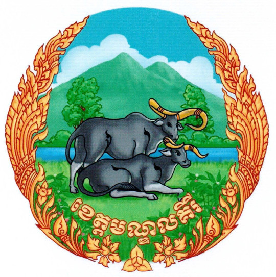
The provincial symbol is decaled by Ministry of Interior via a Prakas No.2408 BrK dated 07 May 2020 on the Establishment of Mondulkiri province Symbol. The symbol has shape and image as follow:
- Round shape including Two oxen, a mountain, a tree, and a circular flower arrangement (Kbach Phni Tes).
- The image of two oxen (wild cows) represents the rich natural resources and wildlife, which it is present in the territory of Mondulkiri province. It also is a favorable location for the conservation of biodiversity and wildlife presently in the five wildlife sanctuaries in Mondulkiri province.
- The mountains and trees image represents the provincial location in the highlands, which are rich in mountains, forests, valleys, streams, cold weather in all seasons and Valuable natural resources, which are the main potential of the province, especially attractive to tourists to visit in all seasons and it is part of the contribution to social and economic development.
- The circular Kbach Phni Tes represents the progress of territorial administration, economic development, social security, morality, equality and gender equity, and the preservation of national cultural traditions under the roof of peace.
Accessibility
- Road: The main road through Mondulkiri is National Road 7 and 8, which starts in Phnom Penh (390 kilometers). Traveler can access to the province via National Road 76 from the southwest along border with Vietnam, and 141 from the north province as well.
- Airway: Mondulkiri is an airport in the capital town of Sen Monorom City. Its runway length is 1,817 meters on laterite surface. Nowadays, there is no service operation. Currently, the project to establish Mondulkiri International Airport type 4C for the short term 2020-2025 (which can land B737, A319/320, DC9-80/MD80) and type 4E for the medium term 2025-2035 (which can land B747/400, A330/340, B777) located about 20 kilometers south of Sen Monorom.
Tourism
Mondulkiri Province has many potential tourist destinations, tourism resorts and many tourism communities that can attract tourists to visit and stay for a long period. However, most tourists only gather in major tourist destinations, such as Bou Sra Waterfall, Phnom Doh Kramom Cultural Resort, Sea Forest Mountain Park, Bai Chao Resort and Coffee Plantation Resort. Here are some of the key tourism resources in the province:
Bou Sra Waterfall (ទឹកជ្រោះប៊ូស្រា): One of the most famous waterfalls in Cambodia, known for its impressive multi-tiered cascade and scenic surroundings. It is a scenic waterfall located in Bousra Eco Park, which is a well-known attraction for both domestic and international tourists. It is approximately 43 km from Sen Monorom downtown, located in Pu Tit village, Bou Sra of Chreada district. The area is full of natural resources such as forests, birds and the spectacular waterfall itself.
Phnom Sang Sne (ភ្នំសាងស្នេហ៍): Located in Chamka Tae village, Spean Mean Chey commune of Sen Monorom city, it is natural hill about 900 above sea level and is a great location to stargaze from the “hilltop observatory resort”. It is often foggy, windy and cold on the hill, which is located along Dak Dam street of Sen Monorom city. Its natural richness provides beautiful scenery that now attracts more and more people to visit, and the mountain has some decorations to help visitors relax.
Chrey Thom Waterfall (ទឹកធ្លាក់ជ្រៃធំ) is another beautiful waterfall, about 45 km from downtown. The waterfall is around 10meters high and creates an amazing natural sound. The view of the waterfall along with the sound of the birds singing makes this waterfall one of the best places to visit.
Chrey Yous Waterfall (ទឹកធ្លាក់ជ្រៃយស់) is one of the most beautiful views as it is surrounded by trees, many over a hundred years old, which provide shade and a cool breeze for visitors. People can swim in two streams, named Trek and Tra.
Kbal Preah Waterfall is surrounded by indigenous farms and residents, about 15 km from downtown in Romnea commune. The waterfall is about 8-10 meters high. Heading to the waterfall, there is a red soil path and it is about 1km to the waterfall, with no vehicle road access. There are many trees and wild herbs, as well as wild fruit trees, to enjoy at this site.
Keo Seima Wildlife Sanctuary: Known for its rich biodiversity, including endangered species with more than 60 species like Asian elephants, gibbons, and various bird species, the sanctuary is located in Sre Preah commune of Keo Seima district. It also homes to 10 natural waterfalls. The sanctuary offers opportunities for wildlife spotting and conservation tourism.
Leng Keav Waterfall, located in Keo Seima district, is a natural tourism site that is untouched and not yet popular among tourists and visitors. The waterfall creates a healing sound and is surrounded by beautiful scenery, including mountains and lush green forests. The waterfall is cool, clear, and good for swimming, and visitors can also enjoy the sounds of wild animals.
Leng Khin waterfall is a beautiful waterfall that is 20m high and 10m wide. It is surrounded by lush forest, making it a great place to relax and swim. The main points of interest are the spectacular waterfall, as well as the mountain, forest, hills, and fresh air. It is located in Pu Hiem village, Sen Monorom commune of O’Raing district.
Monorom Waterfall or Dam Nak Sdach Waterfall is one of the province’s most beautiful waterfalls. The waterfall has three stages ranging from one meter to nine meters in height, and it flows strongest during the rainy season. There are a tremendous number of trees surrounding the waterfall and about 7m from the waterfall there is a huge, long tree log that looks like a bridge which allows people to cross.
O Chhveng Waterfall is a natural attraction site with a very attractive view of a waterfall and mountain. It has a variety of birds which can attract tourists. It is situated in Pu Trom village, Sangkat Romonea, Sen Monorom city.
O Taing Laing Waterfall, Memeng commune of Kaev Seima district, is a scenic tourism site where is surrounded by lush forest and green nature. It is located 58 km from Sen Monorom downtown, and there is a nice place to swim. It is a popular site for both domestic and international tourists. O Taing Laing Waterfall also has dense forests, a spectacular waterfall, fresh air and many hills.
Lu Pran Mountain, called Phnom Tmor by indigenous local villagers, is located in the Pichrea Da district of Mondulkiri province. It is a rocky mountain and surrounded by forests with wild animals, herbs, plants and birds. The site is about 10 hectares total and is located in the middle of the Wildlife Sanctuary of Namleah Mountain. It is located in Bou Sra commune of Pech Chenda district.
Sea Forest Phnom Bai Chow: A viewpoint offering panoramic views of Mondulkiri’s rolling hills and forests, especially stunning at sunrise and sunset. Located in Lao Ka village, Sokh Dom commune of Sen Monorom city, it is one of popular natural attraction sites in Mondulkiri province. It is located on National Road 76, about 10 km from Mondulkiri on the way to Rattanakiri province. Travelers or tourists can stand on the top of mountain and look down, where they can see the stunning natural forest and mountain landscape. The view is breathtaking and really worth seeing, and visitors can also enjoy taking photos of the amazing view.
Doh Kramom Mountain (ភ្នំដោះក្រមុំ) is a popular worshipping place, especially for the local people and indigenous groups. It is a breathtaking hill great for sunset and sunrise, since it doesn’t have any big trees, but is instead surrounded by grass. From the top, tourists can see Saen Monorom city.
Koh Moueleu (កោះម្លូរ) is a natural destination along the Sre Pok River with sand, shallow water, a stream and the shade of trees that visitors can enjoy. There is an animist beliefamong local people who go here to worshipand ask for happiness from territorial spirits who protect this area.
Coffee Plantations (ចំការកាហ្វេ): Mondulkiri’s cool climate is suitable for coffee cultivation. Visitors can tour local plantations, learn about coffee production, and sample locally grown coffee. Chamka Cafe or Coffee Plantation Resort is a private coffee farm located about 3 km northeast of Senmonorom city of Mondulkiri province. It has a beautiful view and many types of flowers as well as fruit, such as durian, pepper, and other fruits. Visitors can also enjoy drinking coffee, enjoy the view of the Coffee Farm and learning the coffee life cycle.
Dak Dam Community-based Ecotourism (សហគមន៍អេកូទេសចរណ៍ដាក់ដាំ) is ecotourism attraction site that has attracted both national and international visitors. Tourists can learn about the daily life of local villagers here, and the environment and views are fantastic. It is situated in Dak Dam commune of O Reang district.
Andong Dong Sne Mountain (ភ្នំអណ្តូងស្នេហ៍) is a popular attraction located in O’Rieng district in Mondulkiri province, located on a natural hill. The grass at this site changes color four times over the course of a year, even though Cambodia only has two seasons (rainy and dry season). The only way to believe this amazing grass is to visit and see the transformation yourself.
Andong Kraloeng Ethnic Bunong Ecotourism, located in Andoung Kraloeng village, Saen Monourom commune of Ou Reang district, is home to wildlife such as gibbons, douc langurs, monkeys, and silver pheasants. It is located in an indigenous village about 25 km from Sen Monorom downtown, and is supported and protected by the Ministry of Interior. The village is rich in natural resources such as forests, wild birds, herbs, and other species, as well as indigenous culture. It also has a beautiful waterfall surrounded by dense forest that creates a spectacular sight.
Elephant and Wildlife Sanctuary is a priceless treasure situated in Mondulkiri province. There are many non-profit projects and organizations working on elephant sanctuaries and. They are doing a great job for both elephants and serving tourists, and visitors will be accompanied by local and company expert to learn not only about elephants, but also wildlife including, birds, animals, and herbs.
The tourism industry in Mondulkiri has grown significantly over the years, transforming the province into a popular destination for both domestic and international travelers. Here's an overview of the key aspects of Mondulkiri's tourism industry:
Accommodation: Eco-lodges and Homestays, various eco-lodges and homestays offer comfortable accommodations while promoting sustainable tourism practices. Staying with local families provides an authentic cultural experience. Resorts and Guesthouses: A range of accommodations, from budget guesthouses to more upscale resorts, are available in Sen Monorom and other parts of the province. There are 82 places of resorts, hotels, Bungalows, equally 1,469 rooms and Guesthouse is 50 places (568 rooms).
Restaurants and Eateries: Local Restaurants and Cafés offer a variety of Cambodian dishes, including regional specialties. Moreover, Street Food offers an authentic way to experience local cuisine, with vendors selling snacks and meals at markets and along the streets. There are 50 restaurants and eateries (equally to 389 chairs).
Transportation Services: Local transportation options, including auto-rickshaw and manual-rickshaw and Moto-taxis, are common and affordable modes of transport for short distances and local travel. Moreover, Car and Bike Rentals are also available for those who prefer to explore the province at their own pace. Additionally, regular bus and mini-bus services connect Mondulkiri to major cities like Phnom Penh and nearby regions.
Other Activities:
- Trekking and Hiking: Mondulkiri’s hilly terrain and dense forests provide excellent opportunities for trekking and hiking. Trails led through scenic landscapes, offering views of waterfalls, wildlife, and remote villages.
- Elephant Experiences: Ethical elephant sanctuaries in Mondulkiri allow visitors to learn about and interact with elephants in a responsible manner, focusing on conservation and animal welfare.
- Bunong Villages: The indigenous Bunong (Phnong) people inhabit several villages in Mondulkiri. Visitors can learn about their traditional lifestyle, culture, and practices, including rice farming, basket weaving, and animist rituals.
- Cultural Tours: Organized tours offer insights into the local customs, traditional music, dance, and handicrafts of the Bunong community.
Mondulkiri’s tourism resources are centered around its natural beauty, cultural richness, and opportunities for eco-friendly and adventure tourism, making it a compelling destination for travelers seeking unique experiences in Cambodia.


