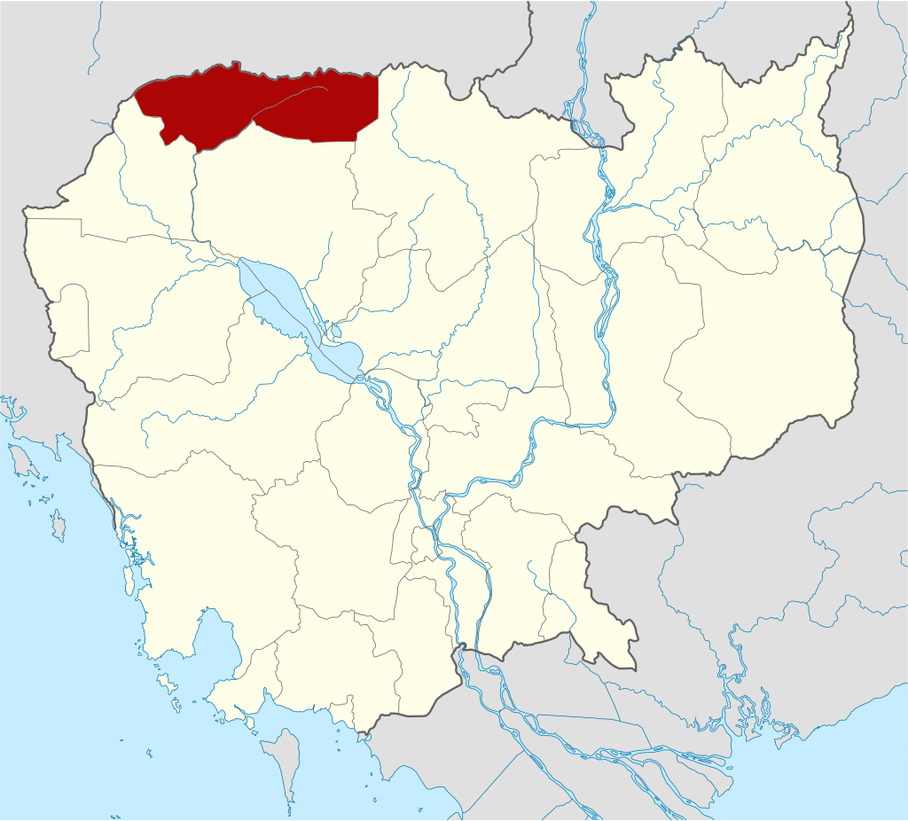
Oddar Meanchey is one of the northern provinces of Cambodia which is 447 kilometers and 469 kilometers from Phnom Penh along National Road 6 (via Kralanh district) and 5 (via Banteay Meanchey province). Oddar Meanchey, covering 6,658.57 square kilometers. Its neighboring provinces are Banteay Meanchey to the west, Siem Reap Province to the south, Preah Vihear province the east, and Border of Thailand to the north.
Oddar Meanchey Province firstly established as a province in 1964 under the Royal Kram No. 194 B.R. dated July 22, 1964. Established for the second time by Royal Kram No. 194 B.R. dated March 01, 1966 under Norodom Sihanouk’s Sangkum regime, but later during mid-1970s became an administrative no-man’s-land, with its status alternating between a province and a district under successive regimes. After the end of 1970s war, all administrative structures were relocated to Siem Reap. Thirdly, the province was reestablished under the Royal Decree No. NS/RKT/0195/07, dated 28 January 1995, by detached from Siem Reap province. However, all structures were not yet operational until April 27, 1999, the Government of Cambodia announced the official launch of the administration.
Present Day, Oddar Meanchey is divided into 4 administrative districts and 1 municipality, Samrong City. The province has three international border gates, the O Smach checkpoint (Samrong City), Choam checkpoint (Anlung Veng district) and Chop Kor Ki checkpoint (Banteay Ampil district). With over 276,000 people, the province is Cambodia’s thirdteenth largest area and eighteenth populous.
History
Oddar Meanchey is a province in northern Cambodia. Its history is deeply intertwined with Cambodia’s broader national history and the political dynamics of the region.
Pre-History or Early History Period
Oddar Meanchey’s history during the Funan and Chenla periods is less well-documented compared to other regions of Cambodia. However, as part of the broader historical landscape of early Cambodia, it likely shared in the cultural and political developments of these eras. Funan is considered the first major Southeast Asian civilization, and it was centered around the Mekong Delta. While the area of present-day Oddar Meanchey is located far from Funan’s core region, the influence of Funan likely extended into the area through trade and cultural diffusion. Funan Kingdom was known for its extensive maritime trade networks that connected it to India, Roman Empire, Persian and others. However, the area of Oddar Meanchey was not a major trade area, it probably has been part of overland routes connecting the interior of the region to more prosperous centers. The spread of Hinduism (Civasime from 1st to 3rd century A.D.) and Buddhism (Mahāyāna since the late of 4th century A.D.), which were prominent in Funan, might have reached Oddar Meanchey during this period. The early spread of Indian cultural and religious practices laid the foundation for the later Khmer civilization.
By the 6th century, the power of Funan declined, and the Chenla Kingdom emerged, with its influence spreading over much of present-day Cambodia, including Oddar Meanchey. During the Chenla period, there were two main regions: Land Chenla and Water Chenla. According to the present-day location, Oddar Meanchey would likely have been part of the Land Chenla. The Chenla period is marked by the construction of early Hindu and Buddhist temples, as well as the development of Khmer art and architecture. Although no major temples from this period are identified in Oddar Meanchey, smaller religious sites or influences may have existed, contributing to the religious landscape that would later flourish during the Angkor period. In terms of religious and cultural practices, would continue to evolve and integrate into the broader Khmer identity that later culminated in the Angkorian period. In Chenla period, people continuously practiced Hinduism (mostly Civasime and rarely Harihara) and Buddhism.
In short, during both Funan and Chenla periods, Oddar Meanchey was likely a peripheral region that nonetheless participated in the broader cultural and political developments of early Cambodia. It would have been influenced by the trade, religion, and political organization of these early kingdoms, setting the stage for its later integration into the Angkor Empire.
The area that is now Oddar Meanchey was once part of the Khmer Empire, which was centered at Angkor, near present-day Siem Reap. The Khmer Empire, which existed from the 9th to the 15th centuries, was one of the most powerful empires in Southeast Asia, and the region would have been influenced by the empire’s culture, architecture, and governance. Oddar Meanchey is located relatively close to the Angkor region, which was the capital and the center of the Khmer Empire. This proximity meant that the area was more directly influenced by the political and cultural developments emanating from Angkor. The Khmer Empire is renowned for its temple-building activities, most famously Angkor Wat. While Oddar Meanchey does not host any temples as grand as those in Angkor, it contains several smaller temple sites from this period, such as Prasat Ta Moan Thom, Prasat Ta Moan Toch, and Prasat Ta Krabey. These temples, situated near the Thai border, were part of a network of religious and administrative sites that helped solidify the empire’s control over its territories. The religious practices in Oddar Meanchey during this period would have followed the broader trends of the empire, initially focusing on Hinduism, particularly the worship of Vishnu and Shiva, and later incorporating Mahayana and Theravada Buddhism.
Post-Angkor Period
During the post-Angkor period, which spans from the 15th century onward, Oddar Meanchey played a significant yet often understated role in Cambodian history. This period followed the decline of the Angkor Empire, which had been one of Southeast Asia’s most powerful and influential states. The post-Angkor era was marked by political instability, territorial fragmentation, and the shifting of power centers, particularly towards the south and east of Cambodia. After the fall of Angkor in the 15th century, the Cambodian capital shifted multiple times, eventually settling in Toul Basan, Longvek, Udong, Chaktomuk (Phnom Penh). The decline of Angkor left many regions, including Oddar Meanchey, more isolated and less directly connected to the central power structures. Oddar Meanchey, being located in the northern part of Cambodia, became a frontier region. It was less influenced by the new centers of power, which were focused on the southern and eastern parts of the country.
During the post-Angkor period, the area of Oddar Meanchey was on the frontier between the Cambodian heartland and the growing influence of neighboring Siam (modern-day Thailand). As a border region, it often served as a buffer zone between the two powers. The area was occasionally contested between the Siamese and the Cambodians. Control over this region shifted back and forth, depending on the political and military strength of the Cambodian kingdom and the Siamese. In later centuries, particularly during the periods of foreign domination (by both Siam and Vietnam), Oddar Meanchey became a region of resistance. Its remote and rugged terrain made it a suitable area for staging rebellions against foreign control.
Colonial Period
During the French colonial period (1863–1953), Oddar Meanchey was part of the Siam. Due to the province’s proximity to the Thai border also made it a strategic location during various conflicts, including those in the 18th till early 20th centuries, when Cambodia was caught between the ambitions of its larger neighbors. From 1795 to 1907, the area of Oddar Meanchey was part of Siamese province of Monthon Isan. Following the return of the adjacent Thai province of Inner Cambodia and Oddar Meanchey to Cambodia in 1907, King Sisowath divided the province into Battambang and Siem Reap (The area of Oddar Meanchey was included with Siem Reap). After the Franco-Thai War, the province was administered by Siam as Phibunsongkhram province from 1941 until 1946. Following French diplomatic efforts at the end of World War II, Cambodia regained control of the province in 1946. The area remained largely underdeveloped and was sparsely populated. After Cambodia gained independence from France in 1953, the region continued to be relatively isolated.
Independence and Conflict Period
The history of Oddar Meanchey province during the second half of the 20th century is marked by the violent conflict that engulfed Cambodia. Oddar Meanchey Province firstly established as a province in 1964 under the Royal Kram No. 194 B.R. dated July 22, 1964. Established for the second time by Royal Kram No. 194 B.R. dated March 01, 1966 under Norodom Sihanouk’s Sangkum regime. During the Cambodian Civil War, the Khmer Rouge used the distant location as a base to fight the Khmer Republic, which was led by General Lon Nol. During the Khmer Rouge era (1975–1979), the region, like much of Cambodia, suffered greatly. After the fall of the Khmer Rouge, many of the group’s remaining forces retreated to remote areas, including Oddar Meanchey, and continued to wage a guerrilla war against the Vietnamese-backed Cambodian government throughout the 1980s and early 1990s (made Anlong Veng their base from 1989 till 1997).
Modern Day
The Khmer Rouge resistance was particularly strong in Oddar Meanchey, and it wasn’t until the late 1990s that the area was fully pacified. In 1998, the Cambodian government launched a “win-win policy” under Prime Minister Hun Sen, which led to the surrender of remaining Khmer Rouge forces, including those in Oddar Meanchey.
Oddar Meanchey was officially established as a province in 1999, carved out from parts of the larger Siem Reap province. Since then, it has seen gradual development, with efforts focused on infrastructure, economic growth, and integration with the rest of Cambodia. The province’s economy is primarily based on agriculture, but there has been increasing cross-border trade with Thailand, and tourism is slowly developing, particularly in areas close to the border and historical sites.
Dignitaries who were former governors of Oddar Meanchey since 1964
There were 12 Governors of Oddar Meanchey Province from 1964-Present, including:
- Mr. Chea Kim Eng (លោក ជា គឹមអេង) 1964-1969
- Mr. Ngoun Nhil (លោក ឡុក ធិច) 20 days in office due to the assassination by Khmer Rouge force
- Mr. Kien Try (លោក គៀន ទ្រី) Unknwon-1974
- Samakmit. Hout Hin (សមមិត្ត ហួត ហ៊ិន) 1975-Unknown
- H.E. Chamroeun Cheat (ឯកឧត្តម ចំរើន ជាតិ) 1999-2000
- H.E. Long Sarin (ឯកឧត្តម ឡុង សារិន) 2000-2001
- H.E. Lai Vireak (ឯកឧត្តម ឡៃ វីរៈ) 2001-2005
- H.E. Kuch Moly (ឯកឧត្តម គុជ ម៉ូលី) 2005-2006
- H.E. Pech Sokhin (ឯកឧត្តម ប៉ិច សុខិន) 2006-2009 and 2009-2013
- H.E. Sar Thavy (ឯកឧត្តម ស ថាវី) 2013-2018
- H.E. Pen Kosal (ឯកឧត្តម ប៉ែន កុសល្យ) 2018-2024
- H.E. Mean Chanyada (ឯកឧត្តម មាន ចាន់យ៉ាដា) 2024-Present
Geography
Oddar Meanchey is a province located in the northern part of Cambodia. It is bordered by Banteay Meanchey to the west, Siem Reap Province to the south, Preah Vihear province the east, and Border of Thailand to the north. Oddar Meanchey is geographically diverse, featuring forests, mountains, and agricultural land.
Topography: The province is characterized by a mix of lowlands, uplands, and mountainous areas. The northern and western parts of Oddar Meanchey are more mountainous, with the Dangrek Mountain range forming a natural border with Thailand. The central and southern parts of the province are flatter, consisting of plains and agricultural fields, which are more suitable for farming.
Climate: The province experiences a tropical monsoon climate, with a distinct wet and dry season. The wet season usually lasts from May to October, while the dry season runs from November to April. Rainfall is generally heavy during the wet season, which contributes to the fertility of the land, particularly in the agricultural plains. However, during the dry season, water scarcity can be an issue in some areas.
Water bodies: There are a small stream that flow through Oddar Meanchey, which originate from the Dangrek Mountains. It is called Stung Sreng (ស្ទឹងស្រែង), which is situated in north-western Cambodia. Its source lies in the southern slopes of the Dangrek Mountains and after traversing through three provinces – Oddar Meanchey province, Siem Reap province and Banteay Meanchey it drains into the Sangkae River. These water bodies are crucial for irrigation and agriculture, especially during the dry season. The province does not have any major lakes or large rivers, but have many man-made reservoirs that are vital for local communities.
Natural Resources, Vegetation and Land Use: Oddar Meanchey is known for its significant forest cover, particularly in the northern and western parts of the province. These forests are part of the larger tropical forest ecosystem found in northwestern Cambodia. The forests are home to a variety of wildlife, although deforestation and land clearing for agriculture have impacted the region’s biodiversity. Oddar Meanchey is home to a few protected areas and community forests, where local communities manage the forests to prevent deforestation and maintain biodiversity. These areas are important for conservation efforts and sustainable development in the province.
- Kulen Brahmadeb Wildlife Sanctuary covers land area of 428,971 hectares, sharing with Siem Reap and Preah Vihear province (126,662 hectares located in Oddar Meanchey)
- Sangh Rukkhavan Wildlife Sanctuary covers land area of 30,254 hectares.
- Banteay Chhmar Protected Landscape covers land area of 84,825 hectares, sharing with Banteay Meanchey province (36,741 hectares located in Oddar Meanchey)
- Preah Vihear-Phnom Dangrek Protected Landscape covers land area of 47,318 hectares, sharing with Preah Vihear province.
- Ang Trapaeng Thmor Protected Landscape covers land area of 24,212 hectares, sharing with Banteay Meanchey province.
- Phnom Preah-Phnom Veng Natural Heritage Site covers land area of 1,492 hectares, sharing with Banteay Meanchey province.
Administrative divisions
As of 2024, the province is divided into 1 municipality (Krong) and 04 districts (Srok), 05 Sangkat and 19 communes (Khum), and 308 villages. Based on population census of 2019, the total population is 276,038 people (female 136,660), the number of households is 56,331 households, and the density is 45 people/km2. Samroung municipality is the seat of government, commonly known Krong Samroung or Samroung City.
- Samroung Municipality (05 Sangkat)
- Orn Lung Veng District (05 Khum)
- Banteay Ampil District (04 Khum)
- Chong Kal District (04 Khum)
- Trarpaing Prasat District (06 Khum)
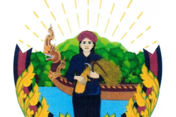
The provincial symbol is decaled by Ministry of Interior via a Prakas No.2038 BrK dated 7 May 2018 on the Establishment of Oddar Meanchey Province Symbol. The symbol has shape, size and image as follow:
- The oval-shaped with the width equal to two-third of the length
- Avalokitesvara bodhisattva, avarta of Vishnu Gof, symbolizes happiness, unification of religion, no religious or other conflicts occur. Where Vishnu is, there will be abundant happiness.
- Chakra represents the territorial administration, powerful authority to eradicate evil
- The Vedas represent the rule of law, especially the Constitution, which is the basic law.
- The stick or mace represents the national defense with a strong national armed force
- The Buddha represents the worship of Buddhism, the only religion of the nation.
- Lime holder or pot of water represents the health sector, there is a holy cure to lead to all suffering.
- The earth represents the environment that provides all the benefits of life.
- Lotus represents education, administration of education, training of good human resources for society
- Conch represents the beautiful traditions of the Khmer people.
Accessibility
- Road: The main road to Oddar Meanchey from Phnom Penh via National Road 6 (via Kralanh district) and 5 (via Banteay Meanchey province)
Tourism Product
Oddar Meanchey is a province in northern Cambodia that, while not as well-known as some other regions, offers a variety of unique and relatively untouched tourism resources. Here are some key attractions and resources in Oddar Meanchey:
Prasat Ta Moan Thom Group (ក្រុមប្រាសាទតាមាន់ធំ): Located near the Thai border, this temple complex is part of a trio of temples and offers insight into the ancient Khmer civilization. The complex includes Prasat Ta Moan, Prasat Ta Moan Toch, and Prasat Ta Krabey.
Ta Moan Thom temple (ប្រាសាទតាមាន់ធំ) was built to dedicate to Shiva in Brahmanism during the Angkorian period, located on the Dangrek mountain range. If there were no trees on the hillside in front of the temple, one would see a beautiful view of the Cambodian lowlands towards South, and if you get out of the temple gate, you can travel on the ancient road from Angkor, while on the nearby side, there is an ancient pond.
Ta Krabei (ប្រាសាទតាក្របី)៖ the site became famous after Cambodian and Thai soldiers fought to take control of the ancient temple. Currently, the temple site has both Cambodian and Thai soldiers standing, but tourists can still visit normally.
Toib Bridge or Teb Bridge (ស្ពានទ័ព ឬស្ពានទិព្វ) is located in Cheung Tien Village, Cheung Tien Commune, Chong Kal District, Oddar Meanchey Province. The bridge was built in the late 12th century during the reign of Jayavarman VII on an ancient road from the former capital of Angkor Thom to Phimai (now in Thailand). The military bridge is built across Stung Sreng, which is 150 meters long, 16.50 meters wide and 10 meters high. The bridge is facing many structural problems, especially on the east side. Over the centuries, the pillars, especially on the east side, have been eroded by strong currents, as well as the floodwaters that brought soil and small trees up to 4 meters high. In addition, due to the dense forest and lack of care, some of the dragon’s statue sandstone was split into pieces. The Ministry of Culture and Fine Arts has started partial conservation and restoration in the first phase in 2015 in the western part and the second phase in 2016 in the eastern part under the 2016 National Budget Support Project of the Royal Government of Cambodia. In the second phase, the Ministry of Culture and Fine Arts preserved and repaired the 2nd to 4th pillars (counting from north to south) and and redeveloped the 50-meter-long dragon statue.
Prasat Khnar (ប្រាសាទខ្នារ) is a three-tower temple built of burnt bricks and decorated with lintels, doors and colonnettes made of sandstone, but was broken and almost collapsed. It is located near Wat Prasat Borey Chey (វត្តប្រាសាទបុរីជ័យ), also known as Wat Tra Nhung Prasat (វត្តត្រញំងប្រាសាទ) in Tra Nhung Prasat district, Oddar Meanchey province. On the way to the temple, there are 1181 wooden staircases that bend between small and large boulders and are surrounded by small and large trees to create a panoramic view.
Damrey Trom temple or Damrey Krap temple (ប្រាសាទដំរីទ្រោម ឬប្រាសាទដំរីក្រាប) ៖ is located in Kork Mon commune, Banteay Ambel district, Oddar Meanchey province, on the Dangrek mountain range, built in the 11th to 13th centuries. The temple has a stone shaped like an elephant, bowed to the ground, this shape proved that the temple is the place where the elephant crouched for the king to sit on his back at this temple.
Da Champey Waterfall (ទឹកជ្រោះដាចំប៉ី)៖ Also known as Ta Thong Cave Waterfall (ទឹកធ្លាក់ល្អាងតាថុង), Chambey Waterfall is located in Roort Champei village, Sangkat O Smach, Samrong City, Oddar Meanchey Province and is about 35 km from the provincial town. It is a natural attraction site with a beautiful scenery, including a 500m long boulder, and the lowest waterfall that is only 1m high, flowing through caves in a circle. There is also a waterfall that is 5m high that is the main attraction of this mountainous site.
O’Svay Waterfall (ទឹកធ្លាក់អូរស្វាយ) is a natural area located in O’Svay Village, O’Svay Commune, Trapeang Prasat District, 105 km from the provincial town. It is a beautiful multi-stage waterfall, which gets its water from the top of the mountain. The waterfall is surrounded by a forest. In addition, it is also a great place for photographers and adventure tourists.
O Teuk Chhol Waterfall (ទឹកធ្លាក់អូរទឹកចោល) is a natural area located in Thmor Daun Village, Kork Mon Commune, Banteay Ampil District, 26 km away from the provincial town. The waterfall has two stages flowing along a small stream. Its first stage is about 1-2 meters high, and the second stage is more than 10 meters high, which then flows down to cascade about 10m high. This waterfall has a beautiful landscape with fresh air and is surrounded by many large trees.
Rolous Thom Canyon or Dey Rolous Thom Resort (រមណីយដ្ឋានដីរលុះធំ) is located 18 kilometers from Oddar Meanchey provincial town. It is a natural canyon site that is different from other places because of its plateau, which is shaped like a pillar of a pagoda or temple. The plateau is like hillocks, with water flowing and high and short walls forming a beautiful and spectacular landscape to look at. Situated in Khnach Ruessei village, Sangkat Bansay Reak of Samraong city, the resort is attracting national and international tourists to visit, especially on weekends and major holidays.
Ta Mok House (ផ្ទះតាម៉ុក)៖ located in Apivat village, Ampil commune, Anlong Veaeng district, it is a historical site that was the house of the former central committee member of Khmer Rouge during Democratic Kampuchea. The special things about the house include the pillars, made of the big trees, and there are hand-drawn works of art such as a map of Cambodia, animals in the jungle, the Preah Vihear temple and Angkor Wat temple. Outside the house, there is an old car, which was abandoned under the sun and rain. On the other side, there is a large iron cage that was a prison for Ta Mok’s prisoners.
Ta Mok’s house, Central House on Dangrek Mountain (ផ្ទះតាម៉ុក ផ្ទះកណ្តាល) is located along Street 68 Choam village, Trapeang Prey commune, Anlong Veng district, about 100 kilometers from Oddar Meanchey provincial town. It was built on the 7th September 1995 covering 3.025 hectares. It is considered a historical attraction site that most people are interested in because a single, whole piece of wood was used as a pillar. It was the house of Tamok but it was already half burnt in 29th January 2014. It has been repurposed and now is a documentary center of Cambodia that shows maps or postcards during the Khmer Rouge regime.
Ta Mok Transport Site (ទីតាំងការដ្ឋានដឹកជញ្ជូនតាម៉ុក) is a war historical site located in Khleang Kandal Village, Trapeang Prey Commune, Anlong Veng District, 86 km from the provincial town. It was built in 1992. It is located on an area of 0.122 hectares and the building is made of wood and brick in the shape of a garage. This repository was a material distribution warehouse during that time.
Pol Pot Crematorium (កន្លែងដុតខ្មោចប៉ុលពត) is a war historical site located in Choam village, Trapeang Prey commune, Anlong Veng district, 84 km from the provincial town. It is a site where Pol Pot, Khmer Rouge Regime Leader or Prime Minister, was cremated.
The Pol Pot trial site (កន្លែងកាត់ទោសប៉ុលពត) is a war historical site located in Choam village, Trapeang Prey commune, Anlong Veng district, 95 km from the provincial town.
The 200 Mountain Bullet Refinery (កន្លែងកែឆ្នៃគ្រាប់កាំភ្លើងលើភ្នំ២០០), a war historical site, is located in Cheung Phnom Village, Trapeang Prey Commune, Anlong Veng District, 95 km from the provincial town. It is a memorable horror historical location. The “central repository” was created on one hectare of land on March 9, 1994. This was Tamok’s depository for producing bullets, and there were 12 individuals working there. The site could generate between 5000 and 6000 bullets, but there is currently only one small reservoir, and the warehouse was demolished by the people following the Khmer Rouge’s incorporation into the royal administration in 1998.
Pol Pot Khieu Samphan’s house (ផ្ទះប៉ុល ពត ខៀវ សំផន) is a war historical site located in O Kranhong village, Trapeang Prey commune, Anlong Veng district, 110 km from the provincial town. Both houses both were built of bricks, concrete, and the roof of asbestos sheets. Pol Pot`s house had a basement to keep documents and necessary materials while Khieu Samphan`s had an office and a fishpond. These houses were built on October 6, 1993, on a total land of 117.06 hectares.
Cheung Phnom Material Warehouse (ឃ្លាំងដាក់សម្ភារៈជើងភ្នំ) is a historical site located in Cheung Phnom village, Trapeang Prey commune, Anlong Veng district, 90 km from the provincial town. It was built for war ammunition including clothes, hats, hammocks and fuel tanks. Nowadays it is just a small place, but there are lots of stories related to the Khmer Rouge Regime that many people want to know. In this place, the lush greenery of nature is also alluring.
Boeung Anlong Veng (បឹងអន្លង់វែង) is a war historical site located in Aphivath village, Anlong Veng commune, Anlong Veng district, 80 km away from the provincial town. The lake covers 417 hectares and shares a border with Thlat commune to the east, with Anlong Veng to the south and with Trapeang Prei to the north. This lake was made in 1990- 1991, and it is an important reservoir with a beautiful landscape. It has crystal clear water and plenty of small and large fish.
The former Ta Mok Hospital (អតីតទីកន្លែងមន្ទីរពេទ្យតាម៉ុក), a war historical site, is located in O Chanchean village, Anlong Veng commune, Anlong Veng district, 80 km from the provincial town. It was built on the 17th October 1993, covering 1614 hectares. The hospital has two buildings. The first building has three stories, and the second building has only the ground floor made of wood. Since 1998 this place has been the main Referral Hospital of this district.
The former Ta Mok School (អតីតទីកន្លែងសាលារៀនតាម៉ុក) is a war historical site located in O Chanchean village, Anlong Veng commune, Anlong Veng district, 80 km from the provincial town. It was built on the total land of 4830 hectares on March 1st, 1993. This school was built with concrete, and has 3 stories and 18 rooms. It is 30m long and 9m wide. It can accommodate from 300 to 400 students but there was only grade 1 to 5 during the Pol Pot regime. Nowadays this school is called is Anlong Veng High School.
Son Sen Crematorium (កន្លែងដុតខ្មោចសុនសេន) is a war historical site located in Cheung Phnom village, Trapeang Prey commune, Anlong Veng district, 87 km from the provincial town. It is a place where Son Sen, who was one of the top leaders of Khmer Rouge regime, and his daughter were cremated. However, it is not a big open space to visit.
Ta Mok Bridge (ស្ពានតាម៉ុក) is a war historical site located in O Chanchean village, Anlong Veng commune, Anlong Veng district, 80 km away from the provincial town. Also known as O’chhick bride, was built on 01st January 1996. It has 53m length and 9m width. The bridge was built to deliver food and ammunition. When visitors stand on the bridge, they can see the surface of the water and it is a common spot for local people to fish.
 Cambodia Oddar Meancheay © Kmusser