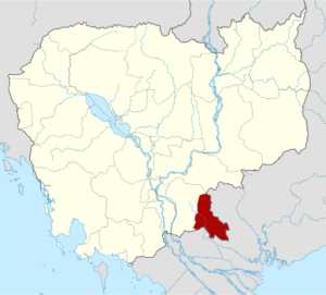
Svay Rieng is, a province of Cambodia located on southeastern, about 125 kilometers from Phnom Penh along National Road 1. The province, covering 2,966.40 square kilometers, bordered by Prey Veng province to the north and west, and Vietnam to the south and east. Svay Rieng’s location near Phnom Penh (about a two and half-hour drive) and its border with Vietnam makes it accessible to travelers passing through. This strategic location could support cross-border tourism and short visits from the capital.
According to some historical accounts, the territory of Svay Rieng province firstly was rich in bamboo and wild mango trees. Some of it was a dense forest with Khlong Tree (ឈើខ្លុង), Gum Tree (ឈើទាល), Koki Tree (ដើមគគីរ) and Pror Chak forests (ព្រៃប្រចាក់), with few fruit trees. Conferring to some legends, after the war, the generals and soldiers stationed at the temple of Preah Neang Chau, Queen of Preah Bat Chey Chetha II, planted 7 types of mango trees, which the people called 7 mango trees: the elephant-headed mango (ស្វាយក្បាលដំរី), the milk mango (ស្វាយខ្ទិះ), the sweet mango (ស្វាយផ្អែម), the Keo Moung mango (ស្វាយកែវមួង), the Wild mango (ស្វាយព្រៃ), the Keo Yak mango (ស្វាយកែវយក្ស), and the Pum Sen mango (ស្វាយពុំសែន). Later, the soldiers and officers who set up camps in Svay Tieb, Romdoul and Rong Damrey provinces picked the fruits to eat and kept seeds to plant at their respective camp site and at their hometowns during their retirement. The mango (in Khmer “Svay”) mostly is grown at the mound area or the ancient pagoda site, so the names of villages, communes, districts and temples often contain the word “Svay”.
In fact, there are 9 communes: Svay Chrum commune, Svay Ang commune, Svay Yea commune, Svay Rumpea commune, Svay Chek commune, Svay Tayean commune, Svay Toeu commune and Svay Rieng commune. There are 15 existing pagodas (in Khmer “Wat”) and 16 ancient mounds (in Khmer “Toul Boran”): Wat Svay Chrum, Wat Svay P’aem, Wat Svay Ang, Svay Phro Hoot, Wat Svay Thom, Wat Svay Yea, Wat Svay Rumpea, Wat Svay (Wat Svay has 2 pagodas), Wat Svay Tayean, Wat Svay Botum, Wat Svay Tor Toem, Wat Svay Chum, Wat Svay Kandal, Toul Svay Anderk, Toul Svay Kantrai Toul, Toul Svay Pum Krorng, Toul Svay Raim, and there are 11 other anciemt mounds. This story is the origin of the name Svay as the basis for naming some villages and districts. During the French protectorate (from 1863-1953) in 1887, an administrative post was established in Svay Rieng village, the current provincial capital, called Svay Rieng Administrative Post, for tax collection and administrative work. This was the main basis for the creation of the name Svay Rieng Province during the first provincial organization in 1922.
Based on the geographical and demographic characteristics, the Khmer-French government at that time required to organize a new province by integrating 3 more provinces into its subordinates and changing the names of those provinces to Khans. Regarding this issue, Assitant of the Svay Rieng regional administration prepared a number of detailed reports to the French governor-general (អគ្គទេសាភិបាលបារាំង) and prepared to present them to the Khmer king to organize the creation of a new province. According to the report, the total of the 3 provinces, namely Romdoul, Svay Teap and Romeas Haek, had a population of about 500 families and only about 50,000 people. This growth and small population made the French-Khmer government at that time decide to merge the above 3 provinces into a single province.
In 1919, the French government found a name for the new region (in preparation for creating a province) by taking the name according to the existing inscriptions there. A meeting at Kraol Ko, with the commune chiefs and district chiefs provided suggestions to the French. Among the commune chiefs, one commune chief, the commune chief of Kraol Ko, named “Promh”, said that this area had the most Svay names, and since the early time. The French also asked the commune chief to count the Svay names. The commune chief counted the following: Svay Chom Rov, Svay Yea, Svay Ang, Svay P’aem, Svay Pror Hoot, Svay Chrum, Svay Thom, Svay Chek, Svay Toeu, Svay Rumpea, Svay Tayean, Svay Teap, Svay Bei Duem (now Duc Ve, Vietnam) as the names for the French. Then they decided to use the name “Svay Rieng”.
After questioning the district chiefs and commune chiefs in Kraol Ko, the French expert asked more about the residents of other villages up to the Chik Pu (ចិកពូ) or Chi Pov (ជីពូវ) area, currently Chi Phu (ជីភូ). The Chi Phu area is mostly inhabited by Chinese people who trade in various goods. This Chi Phu was the name of a Chinese person of that generation, called Dang Khao or a wealthy person, whom the Khmer people around the area often went to buy goods from Chik Pu or Chi Pov and became Chi Phu until today. According to inquiries from the people in the area, the French experts assessed that the name that should be given to this new province was Svay Rieng. Previously, the French had already established a Svay Rieng administrative post in 1889. At the same time, other provinces of the country at that time were also changed, such as Ba Phnom Province changed to Prey Veng Province, Bati Province changed to Takéo Province, Krakor Province changed to Pursat Province, and Tboung Khmum Province changed to Kampong Cham Province.
After conducting demographic and geographical studies and mapping by a team of French Geometry (ក្រុមរេខាគណិត), the French Governor-General in Phnom Penh, accompanied by senior Khmer officials from the Ministry of the Interior, the Ministry of Taxation, and the Oknha Senapadei, representing the Khmer King Sisowath, held a meeting to discuss the establishment of the new province on April 2, 1922. At that time, senior officials agreed to organize the new province in accordance with the situation that France needed to organize for the development of cities and towns in the provinces like in the French provinces. The Khmer King agreed to this request and issued Royal Decree No. 49 dated April 9, 1922, ordering the creation of Svay Rieng Province. Through this Royal Decree, Svay Rieng Province was created by merging three provinces: Romdoul Province, Romeas Hek Province, and Svay Taep Province were renamed to Romdoul Khan, Romeas Hek Khan, and Svay Paep Khan, respectively. All of which were subordinate to Svay Rieng Province. The organization of this Khan was based on the French system, with Khans and Sangkats, etc. In this, Khans were divided into districts, and districts were divided into communes.
This is another new context of provincial organization during the French colonial period. Before the French era, Svay Rieng had three provinces that were created by the Khmer Kings in the post-Angkor period, especially during the Longvek and Oudong periods. According to Dr. Sarin Chek’s documents, Svay Rieng province borders Tan An, a city in Long An province. In this regard, the French took some areas from the Khmer, such as Prey Jet (ព្រៃជេត), Kok Sandek (គោកសណ្តែក), and Svay Bei Duem (ស្វាយបីដើម), and incorporated them into the territory of Cochinchina. As for Rong Damrey Province, which is a province with a large population, rich in businessmen, and easy to collect taxes. Seeing this as an advantage, the French included this province in the territory of Cochinchina. In return, the French paid taxes to the Khmer government for 1 year = 1,000 francs. In particular, the territory connected to Tan An is a geographical area without many people living there, with swampy grasslands and acidic water, making it difficult for the people to live. There was no tax money for the French government, so the French gave it to the Khmer to control. This is why it was included in the map of Cochinchina, leading to the shape of a duck’s beak area until now.
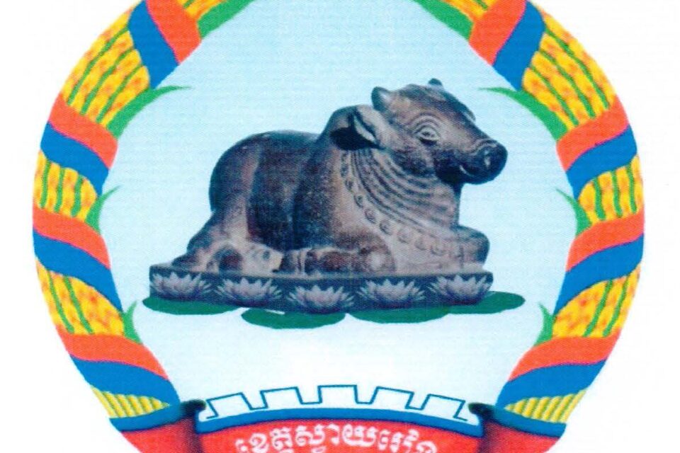
In the beginning, before and after the establishment of Svay Rieng Province, there was no document or evidence that clearly stated the history or symbols of Svay Rieng Province. According to some documents written between 1889-1904, there was no clear symbol. Before and after the merger of the three provinces, Romeas Haek, Romdoul, and Svay Teap, there was no symbol. In 1947, the provincial leadership prepared a statue of a Nandi (is the bull vahana of the Hindu god Shiva) to be placed along National Road No. 1 at the current roundabout. On the other hand, it was to commemorate the virtues of the God of Bull in the story “Preah Ko Preah Keo” and to show the qualities of the character of the bull, which helps serve the agricultural sector in carrying and tilling, which is the core force that the majority of the people of Svay Rieng Province rely on. Until 1957, the statue of the bull was further decorated because some locals believed that it was the statue of the bull in the mythological story “Preah Ko Preah Keo” who came to live in Svay Rieng Province and always brought good luck. However, the statue of a Nandi is not related to the mythological story of the “Preah Ko Preah Keo”. The story of Nandi in the Hindu scriptures is that it was a vahana or a servant of the Hindu god Shiva. In Hindu temples where the statue of the Hindu god Shiva is placed at the entrance to the cave or the stone temples, the statue of the Nandi is always built as a special vahana of the Hindu god Shiva. In particular, the statue of Nandi, built in the 7th century, made of sandstone, is 0.33 meters high and 0.55 meters long. It was discovered between 1930 and 1936 in the Prey Bassac Forest Temple in Bassac commune, Romdoul district (now Svay Chrum district), which is considered a national cultural heritage and was placed in the National Museum by the Ministry of Culture and Fine Arts. In short, the image of the bull and the statue of Nandi have different meanings according to each religion, namely Hinduism and Buddhism. Currently, the Khmer people overwhelmingly respect Buddhism. In particular, People of Svay Rieng province believe that Kandi represents the prosperity and well-being of the people in the lowland area of Svay Rieng province who are engaged in agriculture. By worshipping the Nandi, the people of Svay Rieng province have avoided major dangers and disasters, including the fact that their agricultural products always yield the desired results. In other words, because this statue of Nandi is the oldest ancient artifact among the statues in Svay Rieng province, the people of Svay Rieng province in the 1940s and 1950s adopted the statue of Nandi as the symbol or emblem of Svay Rieng province until today.
Present day, Svay Rieng is divided into 6 administrative districts and 2 municipalities, Svay Rieng City and Bavet City. The province has two international border gates, the Bavet and Prey Voir (ព្រៃវល្លិ៍) checkpoints; Two bilateral gate called Bos Morn (បុសមន) and Samroung, and other four regional checkpoints, the Sre Baraing, Daung, Prey Ta E, and Khsae Dek gates. Given its location along the border with Vietnam, these border crossings facilitate cross-border trade and commerce. The Bavet Border Gate is the primary border crossing and one of the busiest points of entry for goods and people traveling between Cambodia and Vietnam. With over 670,000 people (As of 2023), the province is Cambodia’s 21st area and the sixth most populous.
History
Svay Rieng is a province in southeastern Cambodia, located along the border with Vietnam. It has a rich history shaped by its geographic location, agricultural economy, and cultural interactions with neighboring regions. Here’s an overview of Svay Rieng’s historical development:
Pre-History or Early History Period
Svay Rieng, like much of Cambodia, was part of the ancient Funan Kingdom (1st to 6th century AD) and later the Chenla Kingdom (6th to 9th century AD). These early civilizations laid the foundation for the rise of the Khmer Empire, one of Southeast Asia’s most powerful and culturally significant empires.
During Khmer Empire, which flourished between the 9th and 15th centuries, the area was likely populated by Khmer people and was influenced by the larger religious and political structures of the empire. The region’s proximity to the Mekong River made it an important area for trade and agriculture, particularly rice cultivation.
According to some historical documents, such as Histoire du Cambodge, researched by Adhémard Leclére and the Morha Boros Khmer document, it is stated that during the reign of King Jayavarman VII, several villages and districts were organized to lead the administration. In the plains, the territory of “present-day Svay Rieng” is part of Ba Phnom and Rong Damrey provinces, Prey Nokor, etc. The current Svay Rieng province, according to the conclusions of historians, is located between two provinces, Ba Phnom and Rong Damrey provinces. During the reign of King Jayavarman VII, many historians have confirmed the creation of several provinces in the territory of the Khmer Empire. Rong Damrey province has a mountain called “Phnom Cheung Mideng (ភ្នំជើងមីដែង)” in Khmer, but later changed to “Phnom Tay Ninh Vinh” in Vietnamese, and is currently being developed by Vietnam as a tourist area.
Post-Angkor Period
In the 13th century, during the reign of King Ponhea Yat, several provinces were established, and in the 14th century, there were plans to create more provinces, such as Romdoul, Svay Teap, and Rames Haek, which were separated from Rong Damrey, Ba Phnom, and Tboung Khmum provinces. Svay Teap and Romdoul provinces in the south extended to Tuol Tamok, Kok San Dek provinces (currently in Long An province). The three newly established provinces were required to pay taxes and collect taxes and deposit them in the royal treasury in Ba Phnom province.
In the centuries following the fall of the Khmer Empire, Svay Rieng’s territory fell under the control of the Vietnamese and Thai kingdoms at various times, which led to a series of border shifts and territorial disputes.
Colonial Period
By the late 19th century, during the French colonial period, Cambodia was part of French Indochina, and Svay Rieng was included in the French administrative region of Cambodia. French colonial rule led to the construction of infrastructure, including roads and railways, and the introduction of new agricultural practices, though the area remained relatively underdeveloped compared to Phnom Penh and other major urban centers.
In 1863, France began to colonize the Khmer kingdom. In 1889, France established a new administrative post to assist in the collection of taxes for the French-Khmer governments. Provinces that had previously paid taxes in Ba Phnom Province were transferred to pay taxes at the newly established Svay Rieng administrative post. Then, in 1897, with the assistance of the French protectorate in the administrative organization department, the Khmer King prepared a royal proclamation to organize the Khmer Kingdom and organize the administrative division of the territory according to the French style, dividing it into villages, communes, subordinate to the Khan, District and Province administrative.
During 1920-1921, the French Governor-General in Indochina reorganized some Khmer provinces. Through the reorganization, some provinces were abolished and renamed, and some new provinces were created from administrative posts to provinces, and some old provinces were changed to Khans or Districts according to the demographic situation. Based on the aboved reason, the Khmer King issued Royal Decree No. 49 dated April 9, 1922, ordering the creation of Svay Rieng Province. Through this Royal Decree, Svay Rieng Province was created by merging three provinces: Romdoul Province, Romeas Hek Province, and Svay Taep Province.
During the French protectorate’s control over the Khmer government at that time, the French Governor-General in Phnom Penh arranged for the French governors at each post to have the right to control two or three provinces, depending on the actual situation. In particular, the Post Administration de Soai Rieng (in English Svay Rieng), established in 1889, was the location where the provinces of Romdoul, Svay Teap, and Romeas Haek had to come and pay taxes to the French-Khmer government.
This administrative post was located in Svay Rieng town, in Romdoul province, currently Svay Rieng city. According to the words of Village Elder Mr. Mok Sim (លោកព្រឹទ្ធាចារ្យ មោគ ស៊ឹម): during the colonial period, the French used the Waiko River to travel from Cochinchina to the Svay Rieng administrative area. The French built a port near the Ta Hor Bayan tree (ដើមពោធិ៍តាហោ) on the east side of the rive and stationed troops on a ground called Toul Picquét (ទួលពិកកេត៍) in Daun Sar as a defensive post in the northern part of the province.
In particular, the first road (National Road) began to be built from Cochinchina to Phnom Penh in 1903, crossing the Bavet and the Waiko River. The market was moved to the west of the river and the French administration was organized. Along the first road to the north, the French built a post office, a municipal police station, a wooden provincial hall, a bank, a Red and Black Guard barracks (Garde indigene), a district police station, a sports field, a hospital, and a court. The market next to the river (the current location of the Provincial Department of Information) was demolished and changed in 1968.
During the French colonial period, the French built an airport for French aircraft to land, called the French Airfield, and set up a horse stable to the northeast, more than 200 meters away, called the French Horse Stables. After independence in 1953, the airport was abandoned until 1967, when the governor of Svay Rieng Province, Mr. Hem Ketsana, built a market nearby and named it the Airfield Market (ផ្សារវាលយន្ត), which is still in use today. Svay Rieng Province during the reign of King Sisowath Monivong (1927-1941), was divided into the following districts and regions:
- Chao Vai Khet “ចៅហ្វាយខេត្ត” (Provincial Governor): Oknha Ly Chakrei Athibapdei Dhoranint Indra Reak Pbipheak Ratha Udomkrampahu “ឧកញ៉ាលីចក្រីអធិបតីធរណិន្ទឥន្ទ្រារក្សពិភ័ក្ដិរដ្ឋាឧត្ដមក្រមពាហុ”
- Phu Chuy Khet “ភូឈួយខេត្ត” (Vice Provincial Governor): Pbipheak Chakrei “ពិភ័ក្ដិចក្រី”
- Ballat Khet “បាឡាត់ខេត្ត”: Sneha Chakrei “ស្នេហាចក្រី”
- Chao Vai Srok Rumdoul “ចៅហ្វាយស្រុករំដួល” (Governor of Rumdoul District): Bomrong Chakrei “បំរុងចក្រី”
- Ballat Srok Rumdoul “បាឡាត់ស្រុករំដួល” (Ballat of Rumdoul District): Chumnith Chakrei “ជំនិតចក្រី”
- Chao Vai Srok Svay Teab “ចៅហ្វាយស្រុកស្វាយទាប” (Governor of Svay Teab District): Chey Yo Sangkream “ជយោសង្គ្រាម”
- Ballat Srok Svay Teab “បាឡាត់ស្រុកស្វាយទាប” (Ballat of Svay Teab District): Rithy Sangkream “ឫទ្ធីសង្គ្រាម”
- Chao Vai Srok Romeas Hek “ចៅហ្វាយស្រុករមាសហែក” (Governor of Romeas Hek District): Keamvoin Pbipheak “គាមវ័នពិភ័ក្ដិ”
Independence and Conflict Period
After Cambodia gained independence from France in 1953, Svay Rieng, like other provinces, became part of the newly sovereign nation. However, the region’s location along the border with Vietnam continued to be significant, especially during times of regional conflict.
In the 1960s and 1970s, the Vietnam War and the rise of the Khmer Rouge (the radical communist movement) had a profound effect on the region. Svay Rieng became a site of military activity, with both Vietnamese and Khmer Rouge forces operating in the area. The Khmer Rouge, led by Pol Pot, took control of Cambodia in 1975 and established a brutal regime that lasted until 1979. During this period, Svay Rieng, like the rest of Cambodia, suffered under the Khmer Rouge’s policies of forced labor, mass executions, and starvation.
Following the fall of the Khmer Rouge in 1979 and the establishment of the People’s Republic of Kampuchea (which later became the Kingdom of Cambodia), Svay Rieng, like much of the country, was rebuilding from the devastating effects of the genocide. The border region remained politically sensitive, with tensions between Cambodia and Vietnam continuing to shape local affairs.
In the 1990s and early 2000s, Svay Rieng began to experience gradual economic development, largely driven by agriculture. The fertile land, particularly along the Mekong River, is ideal for rice farming, which remains the backbone of the local economy. There has also been growth in the manufacturing sector, with factories producing garments, a major industry in Cambodia.
Modern Day
Today, Svay Rieng is a peaceful and largely agricultural province, with rice paddies, cassava fields, and other crops dominating the landscape. It also has some small urban centers, such as the provincial capital, Svay Rieng town, which has seen growth due to improved infrastructure and access to trade routes.
Svay Rieng’s proximity to Vietnam has facilitated cross-border trade and cultural exchange, but it also presents challenges related to border disputes, migration, and regional politics. The province is part of Cambodia’s efforts to improve economic ties with its neighboring countries while also strengthening domestic infrastructure and services.
In summary, Svay Rieng’s history is marked by its strategic location, agricultural importance, and the impacts of regional and global conflicts, especially during the 20th century. The province has gradually transformed from a war-torn area into a more stable, economically growing region.
Dignitaries who were former governors of Svay Rieng since 1922
There were 33 Governors of Svay Rieng Province from 1922-Present, including:
- Lok Oknha Ly Hasya (លោកឧកញ៉ា លី ហាស់យ៉ា) 1922-1931
- Lok Oknha Tea San (លោកឧកញ៉ា ទា សាន) 1931-1935
- Lok Oknha Techo Bor Reach Meas Nal (លោកឧញ៉ាតេជោបរវាជ មាស ណាល់) 1935-1939
- Lok Oknha Bun ChankhounThon (លោកឧញ៉ា ប៊ុន ចាន់ឃួនថុន) 1939-1942
- Lok Oknha Chao Sen Kosal (Chhum) (លោកឧញ៉ា ចៅ សែនកុសល ហៅឈុំ) 1942-1944
- Mr. Pen Sam El (លោក ប៉ែន សំអែល) 1944-1945
- Lok Oknha Sena Padei Troeung Karng (លោកឧញ៉ាសេនាបតី ទ្រឿង កាង) 1945-1946
- Lok Oknha Khvan Phin (លោកឧញ៉ា ក្វាន់ ភិន) 1946-1947
- Lok Oknha Chea Chhin Kuk (លោកឧញ៉ា ជា ឈិនកុក) 1947-1948
- Mr. Young Oun (លោក យ៉ុង អូន) 1948-1950
- Mr. Ung Yim Ngoung (លោក អ៊ុង យឹមងួន) 1950-1953
- Lok Oknha Ly Kem Khut (លោកឧញ៉ា លី គឹមឃុត) 1953-1956
- Lok Oknha Teok Peng (លោកឧញ៉ា តឹក ប៉េង) 1956-1959
- Lok Oknha Nhann Thieng (លោកឧញ៉ា ញ៉ាន ធៀង) 1959-1962
- Mr. Tum KemHeng (លោក ទឹម គឹមហេង) 1962-1964
- Mr. Pou Tong Hav (លោក ពូ តុងហាវ) 1964-1966
- Mr. Hem Ket Sana (លោក ហែម កេតសាណា) 1966-1970
- Mr. Bou Tith (លោក ប៊ូ ទិត) 19700 (in office for only 3 months)
- Mr. Koh Chhoun (លោក កោះ ឈួន) 1970-1973
- Mr. Nop Paramond (លោក ណុប ប៉ារ៉ាមុន) 1973-1975
- Samak Mit Chhean aka Ta Veng (សមមិត្ត ឈាន ហៅ តាវែង) 1975-1976
- Samak Mith So aka Ta So (សមមិត្ត សូ ហៅ តាសូ) 1976
- Samak Mith Chan Savan aka Khoun (សមមិត្ត ចាន់ សាវណ្ណ ហៅ ឃួន) 1977
- Samak Mith Phoak Sam An (សមមិត្ត ភោគ សំអន) late 1978
- Samak Mith Chan Seng (សមមិត្ត ចាន់ សេង) 1979-1980
- Samak Mith Heng Sam Kai (សមមិត្ត ហេង សំកៃ) 1980-1982 and 1992-1993
- Samak Mith Mok Soem (សមមិត្ត មោគ ស៊ឹម) 1982-1988
- H.E. Hok Lang Dy (ឯកឧត្តម ហុក ឡង់ឌី) 1988-1991 and 1993-1994
- Lok Phoak Sa Moeun (លោក ភោគ សាមឿន) 1991-1992
- H.E. Loy Sophath (ឯកឧត្តម ឡូយ សូផាត) 1994-1999
- H.E. Hun Neng (ឯកឧត្តម ហ៊ុន ណេង) 1999-2005
- H.E. Cheang Um (ឯកឧត្តម ជៀង អំ) 2005-2016
- H.E. Men Vibol (ឯកឧត្តម ម៉ែន វិបុល) 2016-2023
- H.E. Peng Porsa (ឯកឧត្តម ប៉េង ពោធិ៍សា) 2023-Present
Geography
Svay Rieng Province is located in southeastern Cambodia, bordering Vietnam to the east and south. Its geography is characterized by flat, low-lying terrain, dominated by agricultural land, particularly rice fields. The province is situated in the central part of the Mekong River basin, which has played a significant role in shaping its landscape and economy. Here is a more detailed look at Svay Rieng’s geography:
Topography: The province is predominantly flat, with little variation in elevation across most of the province. The province’s altitude is generally between 10 to 40 meters above sea level. It is part of the broader Mekong River basin, which is a lowland region. The flat terrain of Svay Rieng makes it part of the Mekong River floodplain, which experiences seasonal flooding during the monsoon rains. This floodplain area is particularly fertile and supports intensive agriculture, especially rice cultivation. The majority of Svay Rieng’s land is used for agriculture, particularly rice paddies, but also for crops like cassava, corn, and sugarcane. The fertile soils in the floodplain make it an ideal region for growing these crops.
Water Bodies: The Mekong River runs through the broader region of southeastern Cambodia, and Svay Rieng is influenced by the river system. While the Mekong itself doesn’t flow directly through the province, Svay Rieng is located near several smaller tributaries and canals that drain into the Mekong. These waterways are important for local irrigation, especially during the rice farming season. Given the province’s reliance on rice cultivation, water management is a key aspect of the local economy. The seasonal flooding of the Mekong River contributes to soil fertility, but in the dry season, farmers often rely on irrigation systems and reservoirs to maintain water supply for crops.
Climate: The province, like most of Cambodia, has a tropical monsoon climate characterized by distinct wet and dry seasons. The wet season typically lasts from May to October, with heavy rainfall brought by the southwest monsoon. This period is crucial for rice farming, as the abundant rainwaters help irrigate the fields. The dry season lasts from November to April, with less rainfall and higher temperatures. The dry season is the time when farmers harvest rice and prepare the fields for the next cycle of planting.
Natural Resources, Vegetation and Land Use: The region’s vegetation consists mostly of agricultural fields and some scattered patches of natural forest, particularly in the northern and western parts of the province. The forests are primarily deciduous and tropical, though they are not as dense or expansive as those found in more remote regions of Cambodia.
Svay Rieng’s geography, with its fertile floodplain, waterways, and agricultural focus, makes it one of the most important farming provinces in Cambodia, especially for rice production. The province’s flat landscape, seasonal climate, and proximity to Vietnam further define its role as a key agricultural and trade hub in the region.
Administrative divisions
As of 2024, the province is divided into 02 municipalities (Krong) such as Svay Rien and Bavet and 06 districts (Srok), 12 Sangkat and 68 communes (Khum), and 690 villages. Based on CDB of 2023, the total population is 674,635 people (female 346,5111), the number of households is 160,611 households, and the density is 227 people/km2. Svay Rieng municipality is the seat of government.
- Svay Rieng Municipality (07 Sangkat)
- Bavet Municipality (05 Sangkat)
- Chantrea District (06 Khum)
- Kampong Ror District (11 Khum)
- Rumduol District (10 Khum)
- Rormeas Hék District (16 Khum)
- Svay Chrum District (16 Khum)
- Svay Teab District (09 Khum)
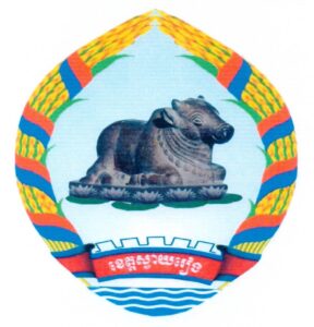
The provincial symbol is decaled by Ministry of Interior via a Prakas No.2109 BrK dated 1 April 2019 on the Establishment of Svay Rieng Province Symbol. The symbol has shape and image as follow:
- Rounded shape
- The image of Nandi (is the bull vahana of the Hindu god Shiva) represents the harmony, abundance, happiness, art, culture and history of Svay Rieng province
- Golden rice husks represent agricultural crops and unity with sincerity, strong will to protect and build a prosperous province.
- Red and blue ribbons represent Khmer identity
- The lotus flower at the bottom of the Nandi represents the worship of the Buddha image in the traditional Buddhist way.
- The light blue background represents the Vaiko River as a source of water for agricultural production and as a breeding ground for fish.
- The image of irrigation system represents canals and pumping stations in the province for irrigation in agriculture
- Rachet represents the industry, which currently has a special economic zone in Svay Rieng that creates jobs and contributes to poverty reduction.
Accessibility
- Road: The province is well-connected by road to other major cities in Cambodia, including the capital, Phnom Penh and others. The National Road No. 1, 13 and 18 are the major highway passing through the province. These roads are the major transportation route for goods and people. Moreover, the main National Road 1 runs from Phnom Penh through Svay Rieng, continuing to Vietnam. This makes Svay Rieng a key transit point for trade between Cambodia and Vietnam.
Tourism Products
Svay Rieng Province, while primarily known for its agricultural economy, is increasingly drawing attention for its potential in tourism, particularly in the areas of cultural heritage, natural landscapes, and its strategic location near the Cambodian-Vietnamese border. While not yet a major tourism destination like Siem Reap or Phnom Penh, Svay Rieng offers several attractions that can appeal to visitors seeking to explore more off-the-beaten-path destinations. Here are the key tourism products in the Province:
Chi Hor Temple (ប្រាសាទជីហោ)៖ is a temple in Prey Kdei village, Kokir commune, Romeas Haek district. About 59 kilometers away to the northeast of provincial town, this temple was built during the 6th century, has patterns and carvings in the style of Sambo Prei Kuk Temple. The temple built on a compound, with 3 meters hign and 50 meters to each corner, and sit along the riverbank on the Cambodia-Vietnam border. The tower was made of laterite and brick, with the main door to the east and 3 other fasle doors. The main door, false doors, and lintel were carved with a flower pattern and made of brick. This temple is the oldest temple in the province.
Prey Kokir Natural Madmade Resort (រមណីយដ្ឋានធម្មជាតិព្រៃគគីរ)៖ is located in the middle of Prey Kokir Community Forest of Trapeang Phlong village, Sangkat Bati, Bavet town, which it is about 7 kilometers (approximately 30 minutes) from the Cambodia-Vietnam international border. Total area of 404 hectares, there is a large pond in the middle of the forest, with small and large plants growing throughout the forest, such as Kakir trees, Smach trees, and a bridge is built to walk through the forest and the colorful flower garden. The resort also offers services include accommodation, Food & Beverage, MICE, and other entertainment services.
Prey Bassac Temple Tourism Site (រមណីយដ្ឋានប្រាសាទព្រៃបាសាក់)៖ Being visited by many people, it is located in Basak village, Svay Yea commune, Svay Chrum district, and is about 8.5 kilometers from the provincial town. Moreover, the temple is located nearby the Waiko river in a vast and scenic marshland, and is popular especially during major holidays. We can reach there by car on concrete road, but in the rainy season we can also travel by waterway on the Waiko River for only 5 kilometers. Prey Bassac has a total area of over 9 hectares bordered to the north and east by the Waiko River, and to the south and west by local villages. In middle of the Bassac Forest, there are two hills in the forest including the Bassac temple hill and Kouk Sampov hill, which are 100 meters apart from each other. The Bassac Temple Bassac temple hill has remained tower with 2 meters high and 5 meters long. The temple was built in the 6th century by King Yasovarman I and in the style of Sambo Prei Kuk temple, and is made of large brick and laterite as the foundation. The Toul Kok Sampov is shaped like a long ship, 25 meters long and 4 meters high, while the sides of the Toul are also arranged in layers of laterite and bricks.
Teuk Vil Natural Resort (រមណីដ្ឋានធម្មជាតិទឹកវិល)៖ It is located in Tuek Vil village, Ampil commune, Romeas Haek district. About 42 kilometers from provincial town, this natural resort has a large pond, which is nice for riding boats, sightseeing, and watching the nature around the pond. There are also cottages, which were built and are owned by local villagers, which provide relaxation and facilitate the serving of meals by local people.
Prek Thnaot Bridge (ស្ពានព្រែកត្នោត)៖ is a natural and man-made resort bordered by Prek Thnaot and connected by Thnaot Bridge (formerly a wooden bridge, currently a steel bridge). Tourists can travel from Svay Rieng city to the west along National Road No. 1, located south of Svay Rieng University, about 2 kilometers away. The location is located on the north side in Pnov Village, Ta Suos Commune, Svay Chrum District, or they can travel along Road No.314B west of Svay Rieng city, about 4 kilometers away. The location is on the south side in Russey Prey Village, Kampong Kok Commune, Svay Chrum District. Prek Thnaot Bridge Resort has a beautiful landscape, clean air like a rural area, with various small and large plants and forests, especially acacia trees, growing on both sides of the road, green and providing cool shade. There are many blooming flowers floating on the water surface mixed with Lotus, Water Lily (ព្រលិត), Star Lotus (រំចង់), and Water Mimosa (កញ្ឆែត).
Svay Rieng has a diverse array of tourism service providers that cater to the needs of visitors, offering everything from guided tours and transportation to accommodation and dining. Below is an overview of the main types of tourism service providers in the province:
Accommodation: As the province becomes more accessible to travelers, there will be demand for affordable and comfortable lodging. Small guesthouses, boutique hotels, and budget-friendly accommodations could serve passing tourists, business travelers, and local visitors. There’s also potential to cater to regional travelers from Vietnam, so properties with cross-border convenience could be a good investment. As of 2024, there are 27 places of hotels (equally 1,759 rooms) and Guesthouse is 66 places (equally 1,061 rooms).
Restaurants and Eateries: Starting a local restaurant or café that serves both international cuisine and traditional Khmer dishes could be a good business idea. Tourism businesses often thrive when they cater to both local tastes and international food preferences. You might also want to focus on unique dining experiences, such as farm-to-table meals or food tours around the province. As of 2024, there are 66 places of restaurants and eateries.
Transportation Services: Given Svay Rieng’s proximity to Vietnam, many visitors use the province as a gateway to cross the border. There’s potential for travel agencies that focus on cross-border transport, including buses, taxis, tuk-tuks, and private car rentals. These services could cater to tourists heading to Vietnam or those traveling through Cambodia.
Gallery

