Pailin Province
Pailin Province is located in the western part of the Kingdom of Cambodia, approximately 371 km from Phnom Penh, which borders: To North, South, and East with Kamrieng district, Samlot district, and Rattanak Mondul district of Battambang province, and to the west with Chanthaburi Province, Thailand. Pailin is covered 1,194,61 square kilometers
According to the Legend, it is stated that in 1846 there is a group of Kola and Khmer Surin hunters settled in Chey Toib district of Chan Bun province (now Thailand called Tap Sai, Chan Borei province). The hunters chased the animals until they reached the forest, mountains, and streams, and found the wild animal (Otter) swimming in the stream. They went down to take a bath, and then they picked up some gems. Later, the news also spread to about 25 of Kola, Lao, and Khmer Surin families who came to settle down to hunt animals and pick gems for sale in the area where the Phe Laeng Toek (Otter Swimming Area).
It was not until 1909 that the French (colonial era) discovered the area and organized it into an administrative area, renaming it as Rattanak Mondul Bor Pailin District. The word "Bor Pailin" is combined with the word "Bor" meaning well and the word "Pailin" is derived from the word "Phe Leang (Otter is swimming)". From then on, the land of diamonds "Bor Pailin" became more and more inhabited until the Sangkum Reastr Niyum era, the Royal Government organized to establish a sub-province of Bor Pailin. But it has not yet been organized into an administrative area.
In 1970-1975, the Khmer Republic established Pailin Mongkul City with 4 Khans: Pailin, Kamrieng, Samlout and Vattanasangkom, in order to facilitate the protection of territorial integrity and administration. In 1975-1979, Pailin was uninhabited. From 1979-1989, Pailin territory was administered by the administration of the State of Cambodia. From 1989-1996, the territory of Pailin was ruled by the administration of Democratic Kampuchea.
Since August 15, 1996, the territory of Pailin has been integrated, including the administrative area, the armed forces and the people, joining the Royal Government of the Kingdom of Cambodia under the Royal Reconciliation and Reunification work of His Majesty King Norodom Sihanouk, and under the wise and skillful leadership in the deepest sense of patriotism. The territory of Pailin was established as Pailin City, which is similar to the provinces in the Kingdom of Cambodia by Royal Decree No. NS / RKOT / 0797/144 dated 31 July 1997. After that, Pailin City was renamed as Province, which is approximately the same as the provincial capital in the Kingdom of Cambodia by Royal Decree No. NS / RKOT / 2018/1384 dated December 22, 2008. Since then, Pailin has had a series of restoration, development and growth.
Present Day, Pailin province is divided into 1 administrative district and 1 municipality. The province has one international border gate, the Promh checkpoint (Sala Krao district). With over 80,000 people, the province is Cambodia’s 23rd in land area and 24th in populous.
History
Pre-History or Early History Period
Pailin Province, like much of modern-day Cambodia, was likely part of the broader political and cultural developments that occurred during the Funan (1st to 6th centuries) and Chenla (6th to 9th centuries) periods. However, specific historical records or archaeological evidence directly linking Pailin to these ancient kingdoms are scarce, primarily due to the limited historical documentation from these early periods and the remote nature of Pailin.
The Kingdom of Funan is considered one of the earliest known Indianized states in Southeast Asia, believed to have been located in the lower Mekong Delta. It was a powerful maritime state that engaged in extensive trade with India, China, Roman, Persian, and it played a crucial role in the spread of Indian culture, religion, and political ideas in the region. There is little direct evidence to suggest that Pailin was a significant center during the Funan period. The region would likely have been part of the hinterlands of the Funan kingdom, possibly inhabited by indigenous groups engaged in subsistence agriculture and forest-related activities. If any connection existed, it would have likely been through trade or as a peripheral area influenced by the broader cultural and economic activities of Funan.
Following the decline of Funan, the Chenla kingdom emerged as a dominant power in the region. Chenla initially started as a vassal state under Funan but eventually grew strong enough to supplant its former overlord. Chenla is often divided into two phases: Land Chenla (more inland and agrarian) and Water Chenla (more coastal and maritime). During the Chenla period, the areas corresponding to modern-day Cambodia, including Pailin, would have seen increased Indian influence, particularly in the form of Hinduism and later Buddhism. Chenla was less centralized than Funan, with power more dispersed among local chieftains. Pailin, being in a more remote and mountainous area, may have been part of the outer regions of Chenla's influence. It might have been governed by local rulers who paid tribute to the central authority in Chenla or maintained some degree of autonomy.
Unlike areas closer to the Mekong River or Angkor, Pailin does not have well-documented archaeological sites from the Funan or Chenla periods. This lack of evidence could be due to various factors, including the region's geography, its distance from the main centers of power, and the possibility that any structures or settlements from these periods have not survived or been discovered. In short, Pailin Province's history during the Funan and Chenla periods remains largely speculative due to the absence of direct evidence. The region was probably a remote part of these early kingdoms, with limited but potentially significant interaction with the broader cultural and political developments of the time. Most of what we know about Pailin's ancient history comes from the broader historical context of Cambodia during these periods.
The area of Pailin was not significantly recognized during the Angkor period (9th to 15th centuries). The Angkor Empire, also known as the Khmer Empire, was centered around the Angkor region, where its capital, Angkor Wat, and other major temple complexes were built. During the Angkor period, the empire's power and cultural influence extended over much of mainland Southeast Asia, including present-day Cambodia, Thailand, Laos, and southern Vietnam. However, the region that is now Pailin was likely a more remote area with less direct involvement in the political and cultural activities of the empire. Pailin gained more significance much later due to its rich gemstone deposits, particularly sapphires and rubies, which attracted attention during the colonial period and beyond. Therefore, while Pailin was geographically within the Khmer Empire's reach, it did not play a central role in the Angkor period's historical and cultural narrative.
Post-Angkor Period
During the post-Angkor period, Pailin's significance gradually increased, especially in relation to its natural resources, but it remained relatively peripheral compared to other more central regions of Cambodia. After the fall of Angkor in 1431, the Khmer Empire fragmented, and the political center shifted southward to areas like Phnom Penh and later Oudong. This period was marked by frequent conflicts with neighboring powers such as the Ayutthaya Kingdom in Thailand and Vietnam, leading to a decline in Khmer territorial control and influence.
Pailin, located in the western part of modern Cambodia near the Thai border, was not a major political or cultural center during this time. During the late 1800s, the area saw an influx of immigrants from Burma who became the Kula people. The Kula settled around Pailin and established structures whose architecture was based off the architecture of Burma.
Colonial Period
However, its role began to change in the 18th and 19th centuries due to its rich gemstone deposits. The area became known for its sapphires and rubies, which attracted traders and settlers, particularly from Siam (Thailand). Pailin and surrounding regions were often under the influence or control of the Siamese (Thai) Kingdom. The Siamese had considerable influence over western Cambodia, including Pailin, due to its proximity to the Thai border. This influence included both political control and economic exploitation of the region's resources. The influx of Thai traders and settlers into Pailin brought economic activity, especially in mining and trading gemstones. This began to shape the region's identity, which was more closely tied to its natural resources than to the political or cultural developments of the Cambodian heartland.
By the late 19th century, with the advent of French colonial rule over Cambodia, Pailin's gemstone wealth became more systematically exploited. The French colonial administration formalized the mining operations and integrated Pailin into the broader colonial economy.
Independence and Conflict Period
Pailin Province is a small but historically significant region in western Cambodia, near the Thai border. Its history is deeply intertwined with the broader history of Cambodia, especially during the 20th century.
Pailin gained significant notoriety during the Khmer Rouge era (1975-1979). The region became a stronghold for the Khmer Rouge, both during their rule and after they were overthrown by the Vietnamese-backed People's Republic of Kampuchea in 1979. The Khmer Rouge leaders, including Pol Pot, used Pailin as a base for their guerilla operations during the 1980s and 1990s. The difficult terrain and its proximity to the Thai border made it a strategic location for the Khmer Rouge to regroup and continue their resistance against the government. Pailin's gem trade became a major source of income for the Khmer Rouge, who controlled the area long after losing power in Phnom Penh. The illicit sale of gemstones helped fund their operations and sustain their forces.
The influence of the Khmer Rouge in Pailin persisted until the late 1990s. The region was one of the last strongholds of the Khmer Rouge, and many former fighters eventually surrendered to the Cambodian government as part of a reconciliation process. As part of this process, many former Khmer Rouge leaders were integrated into the Cambodian political system, and Pailin was granted provincial status in 2001.
The transition to peace in Pailin was slow, and the region remained economically and politically underdeveloped for many years. However, the province's gem trade continued to play a central role in its economy, although the resources have been largely depleted over time.
Modern Day (Peace Process to Present Day)
Today, Pailin is a relatively quiet and sparsely populated province. The province's economy still relies on agriculture and what remains of the gemstone trade. Pailin is also slowly developing as a tourist destination, attracting visitors interested in its history and natural beauty.
The legacy of the Khmer Rouge remains a significant part of Pailin's history, with many former Khmer Rouge members and their families still residing in the province. Despite this, the region has made efforts to move beyond its past, focusing on development and integration with the rest of Cambodia.
Dignitaries who were former governors of Pailin since 1997
There were 4 Governors of Pailin Province from 1997-Present, including:
- H.E. E Chhean (ឯកឧត្តម អ៊ី ឈាន) served as City Governor from 1998-2008 (according to the Royal Decree JS/RKT/0797/144 dated 31 July 1997 the establishment Pailin as City of the Kingdom of Cambodia) and served as Provincial Governor from 2008-2013 (according to the Royal Decree NS/RKT/12018/1384 dated 22 December 2008 tranfromed the title to Pailin Province)
- H.E. Kert Sothea (ឯកឧត្តម កើត សុធា) served as Provincial Governor from 2014-2018
- H.E. Phan Chan Thul (ឯកឧត្តម ផាន់ ចាន់ធុល) 2018-2020
- Lok Chumteav Ban Sreymom (លោកជំទាវ បាន ស្រីមុំ) 2020-Present
Geography
Pailin Province is one of the smaller provinces in western Cambodia, located near the border with Thailand. Here's an overview of its geography:
Topography: The province is characterized by a mix of lowland and mountainous terrain, where little rice is grown. The Cardamom Mountains, a prominent mountain range in Southeast Asia, extend into Pailin Province, giving it a hilly and forested landscape. The terrain is generally more rugged in the western part near the border with Thailand. This makes it very difficult for farmers to rely on subsistence agriculture. Many farmers produce non-traditional crops for the markets, including sesame, mung, soya, maize, cassava, logans etc. Longan, are usually harvested between August and December, occupied 425 hectares to almost 4,000 hectares in 2012 and 2024, respectively.
Climate: Pailin has a tropical monsoon climate, with a distinct wet and dry season. The wet season typically lasts from May to October, with heavy rainfall due to the southwest monsoon. The dry season runs from November to April, with much lower rainfall and higher temperatures.
Water bodies: Several small rivers and streams flow through Pailin Province, primarily originating from the Cardamom Mountains. These water bodies are crucial for local agriculture and daily life.
Natural Resources, Vegetation and Land Use: Historically, Pailin has been known for its rich deposits of gemstones, particularly rubies and sapphires. The mining of these precious stones was a significant part of the local economy, although it has declined in recent years. The province also has fertile soil, supporting agriculture, particularly rice and cassava farming. The Cardamom Mountains in Pailin are part of a larger area known for its rich biodiversity, including various species of plants, animals, and birds. However, deforestation and human activities have impacted the natural environment.
- Samlout Multiple Use Area covers land area of 60,994 hectares, sharing with Battambang province.
- Phnom Yat Natural Heritage Site covers land area of 31,951 hectares.
Overall, Pailin's geography is marked by its mountainous terrain, rich natural resources, and proximity to the Thai border, making it a region of both strategic and economic importance.
Administrative divisions
As of 2024, the province is divided into 1 municipality (Krong) and 01 districts (Srok), 04 Sangkat and 04 communes (Khum), and 93 villages. Based on CDB of 2022, the total population is 80,423 people (female 40,054), the number of6 households is 18,778 households, and the density is 94 people/km2. Pailin municipality is the seat of government, commonly known Krong Pailin or Pailin City.
- Pailin Municipality (04 Sangkat)
- Sala Krao District (04 Khum)
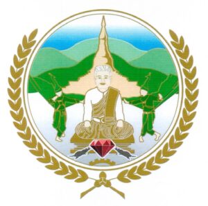
The provincial symbol is decaled by Ministry of Interior via a Prakas No.1588 BrK dated 18 February 2020 on the Establishment of Pailin Province Symbol. The symbol has shape and image as follow:
- The rounded shape
- The two round circles represent the harmony, prosperity and boundaries of the administrative territory of Pailin province under the shadow of complete and lasting peace.
- The gem depicts the history of the origin of the name Pailin, which is derived from the word Phé len, the spoken language of the Kola people who have lived in the area for a long time.
- The mountain range, including Phnom Khieu, Phnom Yat, and Gem, represents a rich natural resource, including forests, animals, birds of all kinds, and mineral resources, which are important resources in all areas of the province.
- Ancient stupas and statues of Yeay Yat accompanied by a pair of peacocks represent a happy life, respect for traditions, tangible and intangible heritage, the ancient civilization of the province and religious beliefs.
- The support rachet and rice husk tied by Kbach Rumduol represent the province's economic development base in agriculture, industry, handicrafts and enterprises under the in-depth reform policy and rectangular strategy of the Royal Government.
- The blue sky represents the auspiciousness of the fresh air of nature, the good environment for human life, animals and the harmony of the local people in the territory of Pailin Province.
Accessibility
- Road: Pailin is well-connected by road to other major cities in Cambodia, including the capital, Phnom Penh, and Battambang. The National Road No. 5 is a major highway passing through the province.
Tourism Producrt
Tourism in Pailin Province is relatively low-key compared to more popular destinations in Cambodia like Siem Reap or Phnom Penh. However, Pailin offers unique attractions, particularly for travelers interested in history, nature, and a more off-the-beaten-path experience.
Phnom Yat Resort (រមណីយដ្ឋានភ្នំយ៉ាត)៖ Located in O Ta Prang village of Sangkat Pailin along national road 57, Phnom Yat is a small hill in the center of Pailin town, topped by a Buddhist temple. On the top of Phnom Yat, there is a pagoda called “Wat Kiri Ratanaram Phnom Yat or Wat Phnom Yat”. There are many ancient constructions (built during the 20th century), new constructions, and hermitages (spirit house which part of animism) such as Chola Moni stupa (Chola Moni Jayatee), Lok Yeay Yat hermitages, 21-meter-tall statue of Buddha defeating the devil, Preah Se Ameti 8-direction temple (សំណង់ប្រាសាទ៨ទិស ព្រះសិអាមេតី), Preah Ko Preah Keo hermitage, etc. This site is sacred to the local population and has a deep cultural and historical significance, particularly for the Kola people, who migrated to the area from Myanmar in the 19th century. Visitors can explore the pagoda, shrines, and the surrounding gardens, which offer panoramic views of the surrounding landscape. The hill also has a series of small stupas and a shrine dedicated to local spirits.
Wat Rattanak Sophoan (វត្តរតនសោភ័ណ ហៅថា វត្តកោងកាង) ៖ Located near Phnom Yat, Wat Rattanak Sophoan is one of the oldest temples in Pailin. The temple complex includes several ancient buildings, statues, and murals that reflect the rich religious heritage of the area.The temple is particularly famous for its large reclining Buddha statue and intricate carvings. It’s a peaceful place for visitors to observe local religious practices and learn about Cambodian Buddhism.
Rohat Teuk Resort (រមណីយដ្ឋានរហាត់ទឹក) is a natural man-made resort located in Suon Ampov Lech Village, Sangkat Pailin, Pailin City, Pailin Province. This resort is about 2 kilometers from the Independence Monument, in direction to the north through Po Mearam called Wat Pahi (ពោធិមារាម ហៅវត្តប៉ាហ៊ី). Travel from the Wat Pahi about 1 km, and turn right for travel along the trail for about 100 meters to reach the resort. The resort is located in a natural stream with clear water flowing indefinitely. There is a beautiful and comfortable private pinic huts along the bank of the stream for tourists to sit and enjoy food, gathering with friends and family. In the stream, a drainage dam is built and there is a large waterwheel in the center, which in the past was a hydroelectric dam in a nearby village. In addition, the resort also has a swimming pool, a flower garden and many natural wildlife statues to enjoy.
Chamkar Khnor Waterfall Resort, also known as Boryakha (រមណីដ្ឋានទឹកធ្លាក់ចម្ការខ្នុរ ឬ គេហៅបយ៉ាខា), is a popular resort that attracts a large number of national and international tourists, both Cambodians and foreigners. To reach the resort, you are able to access from Battambang provincial town along National Road 57 to the west, which is about 80 kilometers to Pailin city. Then we continue to southwest, about 5 to 6 kilometers, passing through a trail will be able to find a resort. This resort was created by a family and was named Chamkar Khnor Resort or Bor Yakha Waterfall Resort, located next to the river or waterfall in Bor Huy Tbong Village, Bor Yakha Sangkat, Pailin City, Pailin Province.
Phnom Jing Chak Dam Resort (រមណីយដ្ឋានទំនប់ទឹកភ្នំជីងចក់) is a newly established man-made tourist site about 4 km from the city, located in Thmey Village, Sangkat Toul Lvea, Pailin City. It built in 1940s as a water tank that stored the water from Kbal Damrei mountain to serve agriculture. The facilities consist of two crossing bridges, rowing boat service, small huts with food and beverage services, and flower gardens.
Kbal Damrey Waterfall Natural Resort (រមណីយដ្ឋានធម្មជាតិទឹកធ្លាក់ក្បាលដំរី ឬទឹកធ្លាក់បរហ៊ុយ) is located in Bor Huy Cheung Village, Sangkat Boryakha, Pailin City. It is a 32-storey cool waterfall that flows from the top of the mountain. This waterfall provides enjoyment with natural beauty, including plants and birds’ sound.
O’Tavao Waterfall or Phnom Khiev Waterfall Natural Resort (រមណីយដ្ឋានធម្មជាតិទឺកធ្លាក់អូរតាវ៉ៅ ឬទឹកធ្លាក់ភ្នំខៀវ) is located in Khlong Village, Sangkat O Tavao, Pailin City, Pailin Province. This scenic waterfall is located about 20 kilometers from Pailin town, surrounded by lush forest. It’s a popular spot for locals and visitors alike, particularly during the rainy season when the water flow is at its peak. The waterfall offers a refreshing break, with opportunities for swimming or simply enjoying the natural beauty of the area. There are also picnic spots around the site.
Pailin is gradually developing its tourism infrastructure, though it remains relatively basic compared to other parts of Cambodia. The province is accessible by road from Battambang and Phnom Penh, with public buses and private taxis being the most common means of transportation. Accommodation options are limited but growing, with several guesthouses and small hotels catering to visitors. The best time to visit Pailin is during the dry season, from November to March, when the weather is cooler and more pleasant.
Tourism in Pailin Province is ideal for those looking to explore Cambodia’s more remote and historically rich regions. It offers a combination of natural beauty, cultural heritage, and historical significance, making it a unique destination for intrepid travelers.


